Douglas Deur
Douglas Deur, Ph.D. is a research professor in the Department of Anthropology at Portland State University and Adjunct Professor of Environmental Studies at the University of Victoria (B.C.). As a cultural ecologist, his work centers on the relationship between human, primarily Native American, communities and their environments. He also directs research on similar themes for National Parks throughout the western United States. His writings have appeared in Oregon Historical Quarterly, Human Ecology, Journal of Ethnobiology and BC Studies; his book, Keeping it Living was the first book-length treatment of plant cultivation traditions among the tribes of the coastal Northwest.
Author's Entries
-
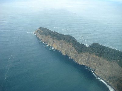
Cape Lookout
Cape Lookout, one of the most prominent landmarks on the Oregon Coast, is a long, narrow promontory of rugged basalt that stretches over a mile and a half into the Pacific Ocean, approximately ten miles southwest of Tillamook. The cape is remarkable for its long oceanward reach and sheer …
Oregon Encyclopedia
-
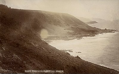
Cape Perpetua
Cape Perpetua juts into the Pacific Ocean about two miles south of Yachats on the central Oregon Coast in Lincoln County. Captain James Cook—who viewed the cape from the sea, but never set foot on it—bestowed its present name on March 7, 1778, to honor Saint Perpetua on her …
Oregon Encyclopedia
-
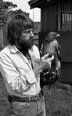
Dan Deuel (1946-2006)
Dan Deuel was the founder of Free Flight, an all-volunteer bird and marine wildlife rehabilitation program in Bandon, Oregon, that was responsible for saving hundreds of birds and coastal mammals on the south coast since 1976. Known as the “birdman of Bandon,” Deuel was admired for his courage …
Oregon Encyclopedia
-
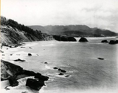
Ecola State Park
Ecola State Park stretches for 1,023 acres from the north end of Cannon Beach to Seaside on Oregon’s north coast. The park encompasses hulking Tillamook Head, which rises over a thousand feet above the ocean, and miles of beaches, smaller headlands, coves, and iconic sea stacks. The rugged shoreline of …
Oregon Encyclopedia
-
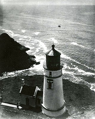
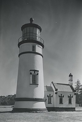
Heceta Head Lighthouse
Heceta Head Lighthouse stands 205 feet above the Pacific Ocean on a bluff carved out of the west side of 1,000-foot-high Heceta Head, twelve miles north of Florence. The light shining from the 56-foot-high tower flashes a white beam for eight seconds every minute. Visible for twenty-one miles, it remains …
Oregon Encyclopedia
-
Hobsonville Indian Community
The Hobsonville Indian Community was a Native settlement on Tillamook Bay, just southeast of Garibaldi on Miami Cove. Tillamook tribal villages, including Kilharhurst, fronted this shoreline well before Native encounters with Europeans, and it is near this location that Captain Robert Gray—commanding the Lady Washington in August 1788—made …
Oregon Encyclopedia
-
Indian Place (Seaside)
Indian Place was a Native community on the Necanicum River estuary in present-day Seaside, on the north Oregon Coast. Though the community was a successor to traditional settlements in the area, including Necotat and Neacoxie, Indian Place refers to a community of families that coalesced at the site throughout …
Oregon Encyclopedia
-
Neahkahnie Mountain
Neahkahnie Mountain, about twenty miles south of Seaside, is a prominent landmark in Oregon Coast geography, history, and lore. Standing 1,680 feet high, the basalt edifice is both a peak and a headland. Formed by Miocene lava flows surging down the ancestral Columbia River channel roughly 15 million years ago, …
Oregon Encyclopedia
-
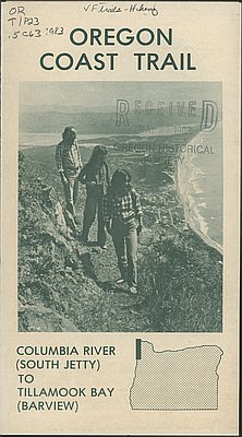
Oregon Coast Trail
Winding for 382 miles along the Oregon Coast, the Oregon Coast Trail is the most extensive and popular recreational trail built and maintained by the State of Oregon. The Coast Trail consists in part of formally designated and maintained trails over majestic headlands, often cutting a narrow swath through otherwise …
Oregon Encyclopedia
-
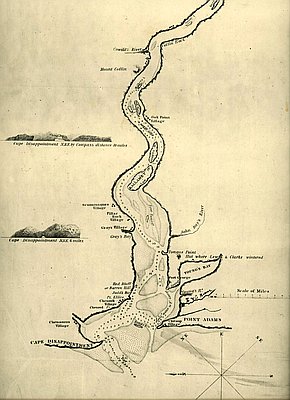
Point Adams
Located at the mouth of the Columbia River and marking the extreme northwestern corner of Oregon, Point Adams is a pivotal landmark in the geography and history of the state. For the Clatsop people, this was the site of the prominent village, Klaát-sop, for which their nation was named. The …
Oregon Encyclopedia
-
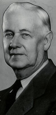
Samuel H. Boardman (1874-1953)
As the first state parks superintendent in Oregon, serving from 1929 to 1950, Sam Boardman is often called the father of the state park system. He had a germinal role in building a system that attracted a steadily increasing number of visitors, and he was the catalyst for the state’s extensive …
Oregon Encyclopedia
-
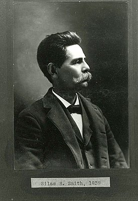
Silas Bryant Smith (1839-1902)
Silas Bryant Smith played a key role in recording the traditions, religions, and customs of the Clatsop people in nineteenth-century Oregon. A prominent historian of the region, he successfully bridged the two traditions, Clatsop and EuroAmerican, that he inherited from his parents. He also won the first Native land claims …
Oregon Encyclopedia
-
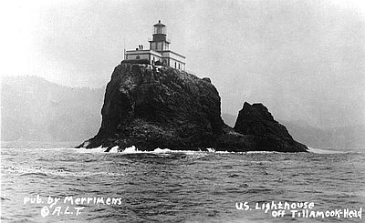
Tillamook Rock Lighthouse
Tillamook Rock Lighthouse sits on a rock a mile offshore of Tillamook Head in Clatsop County, Oregon. Operating from 1881 to 1957, the lighthouse was nicknamed Terrible Tilly for its ferocious storms and the difficulties facing lighthouse keepers stationed there. It was the most expensive lighthouse built in the United …
Oregon Encyclopedia
-
Umpqua River Lighthouse
The Umpqua River Lighthouse, Oregon’s first, was built twice. The U.S. Office of Coast Survey in 1849 selected the mouth of the Umpqua River as one of the first sixteen lighthouse locations for the West Coast. The survey sought to identify locations for a string of lighthouses detectible to mariners …
Oregon Encyclopedia