The legacy of redlining—the spatial distribution of poverty, housing, green space, industrial plants, and highways—shaped where people in Portland have experienced the effects of climate change. Established in the 1930s, redlining is a discriminatory practice of denying a creditworthy applicant a housing loan in neighborhoods that are deemed risky because of their ethnic or racial makeup. The practice persisted until it was outlawed by the Fair Housing Act of 1968. Despite the ban, however, tacit agreements among real estate agents, lenders, and sellers continued to perpetuate housing segregation in Portland into the 1990s. As the effects of climate change have become more severe, those parts of the city that were shaped by redlining have experienced warmer temperatures, disproportionately affecting people of color, low-income groups, and houseless populations.
Redlining and the Legacy of Exclusion Laws
Redlining in Oregon was as much a process of disinvestment and home devaluation as it was an exclusion of people from some neighborhoods based on race and perceived worth. In 1934, the Federal Housing Administration created the Home Owners’ Loan Corporation (HOLC) in response to the Great Depression and the banking crises that resulted from failing home loans. Housing prices were declining, and the FHA allowed homeowners who were at risk of foreclosure to refinance their mortgages at low interest rates. That relief, however, was only accessible to whites who owned property in neighborhoods that were not racially integrated.
HOLC produced color-coded Residential Security Maps for 239 cities in the United States, including Portland, designating four categories of risk for real estate investment: Red/Grade D (hazardous/risky), Yellow/Grade C (declining), Blue/Grade B (still desirable), and Green/Grade A (best). The maps assigned investment risk to entire neighborhoods based on a number of factors, including the race of residents, home values, and the presence of industry. In practice, this evaluation targeted Blacks and other people of color, disenfranchising them from owning homes and reducing their access to quality housing, geographic mobility, and generational wealth. Their neighborhoods often declined due to lack of investment and became vulnerable to development and urban renewal programs.
Oregon has a long history of legal racial discrimination, beginning in 1844 when the Provisional Government of Oregon instituted Black exclusion laws. Property deeds included racial covenants directing that a house “shall not be used or occupied by Chinese, Japanese, or Negroes except that persons of such races may be employed as servants.” In 1859, the Oregon State Constitution banned any “free negro, mulatto, not residing in the state at the time, from living, holding real estate, and making any contracts within the state.” In 1919, the bylaws and code of ethics of the Portland Real Estate Board forbid realtors to sell property in white neighborhoods to anyone of an excluded race. Many Portland neighborhoods—including Laurelhurst, Mocks Crest, Sabin, and Kenton—used restrictive covenants to prohibit the sale of property to people who were Black, Italian, Greek, Armenian, American Indian, Mexican, Japanese, and Chinese. If the restricted covenants in a neighborhood had expired, were near expiring, or did not exist, then HOLC gave it a lower rating and no loans were approved for that area.
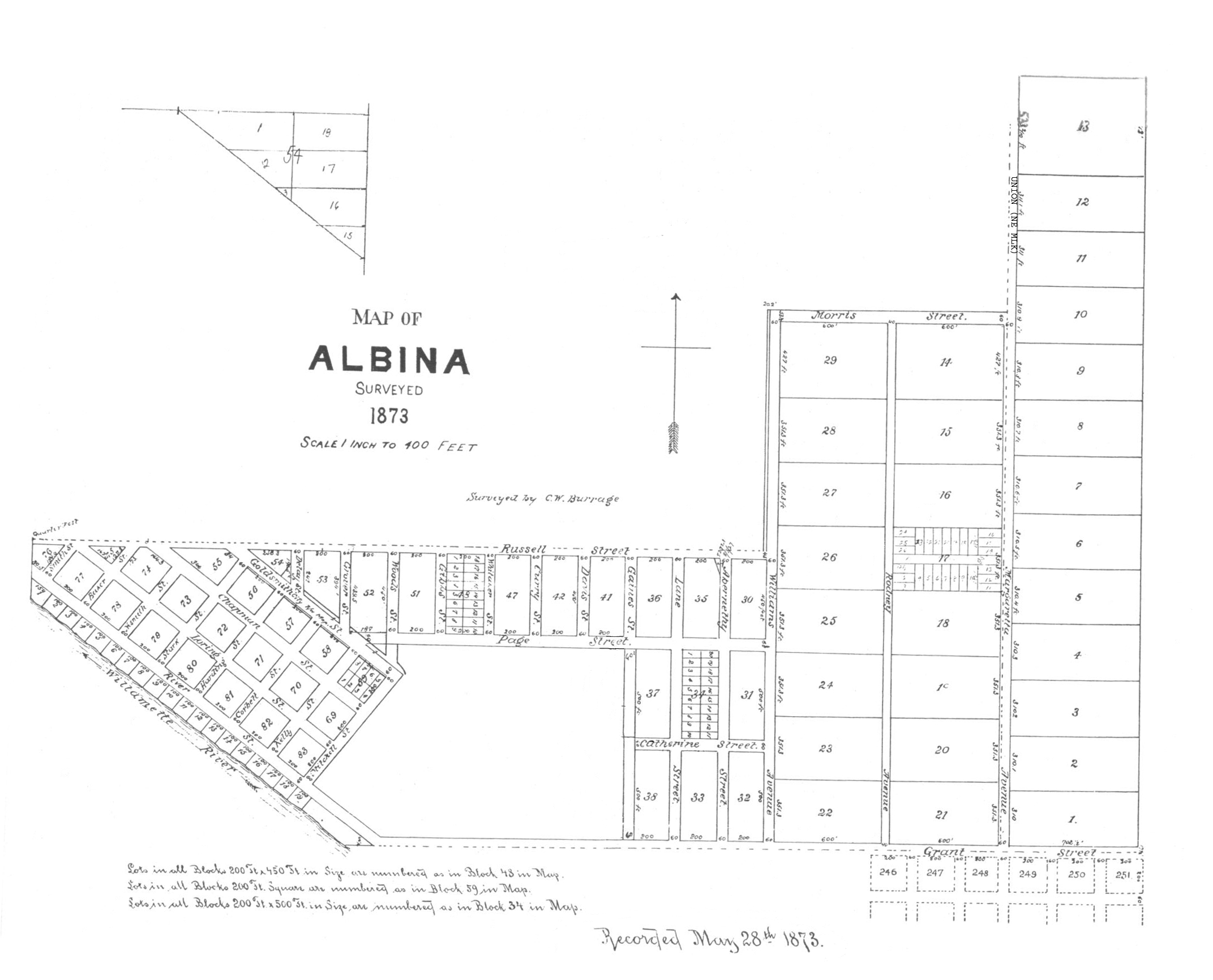
Between 1910 and 1940, the real estate industry, local government, and private landlords colluded to segregate more than half of Portland’s Black population of 1,900 people into Albina, a city on the east side of the Willamette River that had been annexed into Portland in 1891. Beginning in 1942, when 23,000 Black workers migrated to Portland to take jobs at the Kaiser shipyard on Swan Island, the Housing Authority of Portland (HAP) restricted them to housing developments in Vanport and Guild’s Lake. HAP closed the housing at Guild’s Lake at the end of World War II and the Columbia River flooded Vanport on May 30, 1948, displacing more than 5,300 families, about 20 percent of them African American. By 1960, four out of five Black Portlanders lived in the 4.3 square miles of the Albina neighborhood.
After decades of disinvestment, the Albina neighborhood entered a period of slow decline after it was targeted for urban renewal. In 1956, Portland voters voted to build Memorial Coliseum in the Eliot neighborhood, a project that destroyed commercial establishments and 476 homes, many of them owned or inhabited by Black people. At about the same time, the Oregon State Highway Department demolished long stretches of houses and businesses in Albina to make way for Interstate 5, decreasing the tree canopy and increasing the amount of impervious surfaces that use heat-retaining materials. As temperatures rise because of climate change, redlining and urban renewal projects have put Oregon residents like those in Albina at risk.
Climate Change, Urban Heat Islands, and Health
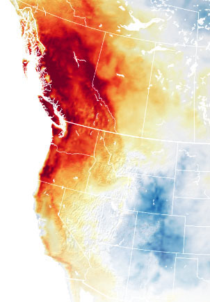
Climate-induced heat in Oregon is projected to increase by an average of 5°F by the 2050s and 8.2°F by the 2080s, with the greatest seasonal increases occurring during summer. The number of days per year exceeding 90°F degrees will likely increase in many inland areas of the state, threatening the well-being of children, the elderly, individuals with pre-existing health conditions, and outdoor workers.
Scientists have demonstrated that land-surface temperatures in urban areas that experienced redlining are warmer than nonredlined areas. These heat islands, as they are called, suffer from higher temperatures because the buildings, roads, pavements, and concrete surfaces are so concentrated that they absorb and emit more heat than natural landscapes do. In Portland, some of the hottest historically redlined neighborhoods, where there are fewer trees and more highways, parking lots, and industrial plants, are Albina, Boise, King, Alberta, Lents, and Cully. Those areas also have a high concentration of air pollution, and more of their residents suffer from health problems.
Exposure to severe heat can have devastating effects on human health, productivity, and well-being. Excessive urban heat is associated with heat strokes, dehydration, and decreased learning, and high ozone levels caused by high temperatures and air pollutants increase the incidents of cardiorespiratory illness, kidney disease, mental illness, and death. During the 2021 heat wave, Multnomah County implemented a number of interventions for managing extreme heat, including opening cooling shelters, offering free water and electrolytes, and providing transportation to cool spaces. Nevertheless, at least seventy-two people died in Multnomah County when temperatures reached 116°F. Many were elderly people in neighborhoods that had been redlined.
In Oregon, only 25 percent of multifamily residences and 68 percent of single-family residences and manufactured homes have cooling systems. Many also lack adequate green space. For decades the city’s development code allowed builders of multifamily complexes to cover an entire lot, with no provisions for green space or vegetation. In 2015, following the implementation of Title 11 Trees, the city’s Tree Code, Portland expanded its tree-planting programs and required that 15 percent of every new construction lot be used for green space.
While the Tree Code guarantees that trees and parks are a focus in city planning, Portland Parks and Recreation reported in 2022 that tree canopy in the Portland area had dropped from 30.7 percent in 2015 to 29.8 percent in 2020. Over a five-year period, the city lost an estimated 800 acres of canopy, the equivalent of Mount Tabor Park. Portland’s east side, which is the hottest part of the city, saw an even bigger loss of tree canopy. Residential areas lost 523 acres of trees during this period due to new housing developments and remodeling, and newer trees are not growing fast enough to make up for those losses. More commercial and residential buildings in places such as Lents, in southeast Portland, mean that residents can find little refuge on extremely hot days.
The State of Oregon has taken some corrective steps to manage the effects of heat on people who live in urban areas, including those who live in neighborhoods with a legacy of redlining. In 2017, Governor Kate Brown signed Executive Order No.17–20 to accelerate energy efficiency in the built environment and reduce greenhouse gas emissions. The order called for solar-ready building construction, prioritizing energy efficiency in affordable housing to reduce utility costs, and ensuring carbon-neutral operations for new state buildings. In 2018, Portland voters approved the Portland Clean Energy Community Benefit Funds, a $60 million annual funding program aimed at accelerating clean energy, green infrastructure, regenerative agricultural projects, and the development of a clean energy workforce. PCEF prioritizes low-income residents and people of color.
-
![Green = Best; Blue = Still desirable; Yellow = Definitely declining; Red = Hazardous]()
Map of Portland color-coded by the Home Owners' Loan Corp..
Green = Best; Blue = Still desirable; Yellow = Definitely declining; Red = Hazardous Courtesy Mapping Inequality -
![A treeless street in North Portland.]()
N. Michigan Ave., Albina and Killingsworth, Portland, 1941.
A treeless street in North Portland. Oregon Historical Society Research Library, OrgLot1284_0253_12 -
![]()
A residential street in Portland's affluent West Hills, 1947.
Oregon Historical Society Research Library, OrgLot1284_1304_3 -
![]()
A signed housing covenant agreement for a home in Mocks Crest, Portland, 1926. Signed by John and Elizabeth Yeon..
Oregon Historical Society Research Library, Mss 2606, Mock-Yeon Family papers
Related Entries
-
![Albina area (Portland)]()
Albina area (Portland)
By the late 1880s, Albina, located across the Willamette River from Por…
-
![Climate Change in Oregon]()
Climate Change in Oregon
Within a few hundred miles in Oregon, you can see snowy volcanoes, parc…
-
![Heritage Trees of Portland]()
Heritage Trees of Portland
The Heritage Tree program in Portland celebrates and protects trees tha…
-
![Housing Authority of Portland]()
Housing Authority of Portland
The Housing Authority of Portland was created in 1941 in response to th…
-
![The 2021 Pacific Northwest Heatwave (Heat Dome)]()
The 2021 Pacific Northwest Heatwave (Heat Dome)
A historic heatwave affected Oregon and the greater Pacific Northwest d…
-
![Vanport]()
Vanport
In its short history, from 1942 to 1948, Vanport was the nation’s large…
Related Historical Records
Map This on the Oregon History WayFinder
The Oregon History Wayfinder is an interactive map that identifies significant places, people, and events in Oregon history.
Further Reading
Gibson, Karen J. "Bleeding Albina: A History of Community Disinvestment, 1940-2000." Portland State University. Urban Studies and Planning Faculty Publications and Presentations, 2007
Hillier, Amy E. "Residential Security Maps and Neighborhood Appraisals: The Home Owners' Loan Corporation and the Case of Philadelphia." Social Science History 29.2 (Summer 2005): 207-233.
Smith, Greta. "'Congenial Neighbors': Restrictive Covenants and Residential Segregation in Portland, Oregon." Oregon Historical Quarterly 119.3 (Fall 2018): 358-364.
Heaviside, Clare, Helent Macintyre, and Sotiris Vardoulakis. "The Urban Heat Island: Implications for Health in a Changing Environment." Current Environement Health Reports, July 10, 2017.
Title 11 Trees of 2022, Ordinance 191030, City of Portland.
"Tracking Portland's Tree Canoppy Cover." Portland Parks and Recreation, January 2022.