By the late 1880s, Albina, located across the Willamette River from Portland, was the fastest growing city in Oregon. In July 1891, the city was annexed by the City of Portland, which at the time existed only on the west side of the river. East Portland, south of Albina, was also annexed, and Portland grew to more than twenty-six square miles. As a result of the annexation, much of the city’s residential population began shifting to the east side of the river. Today, the Albina area of Portland includes the neighborhoods of Eliot, Boise, King, Humboldt, Overlook, Irvington, and Piedmont, all in the north and inner northeast parts of the city.
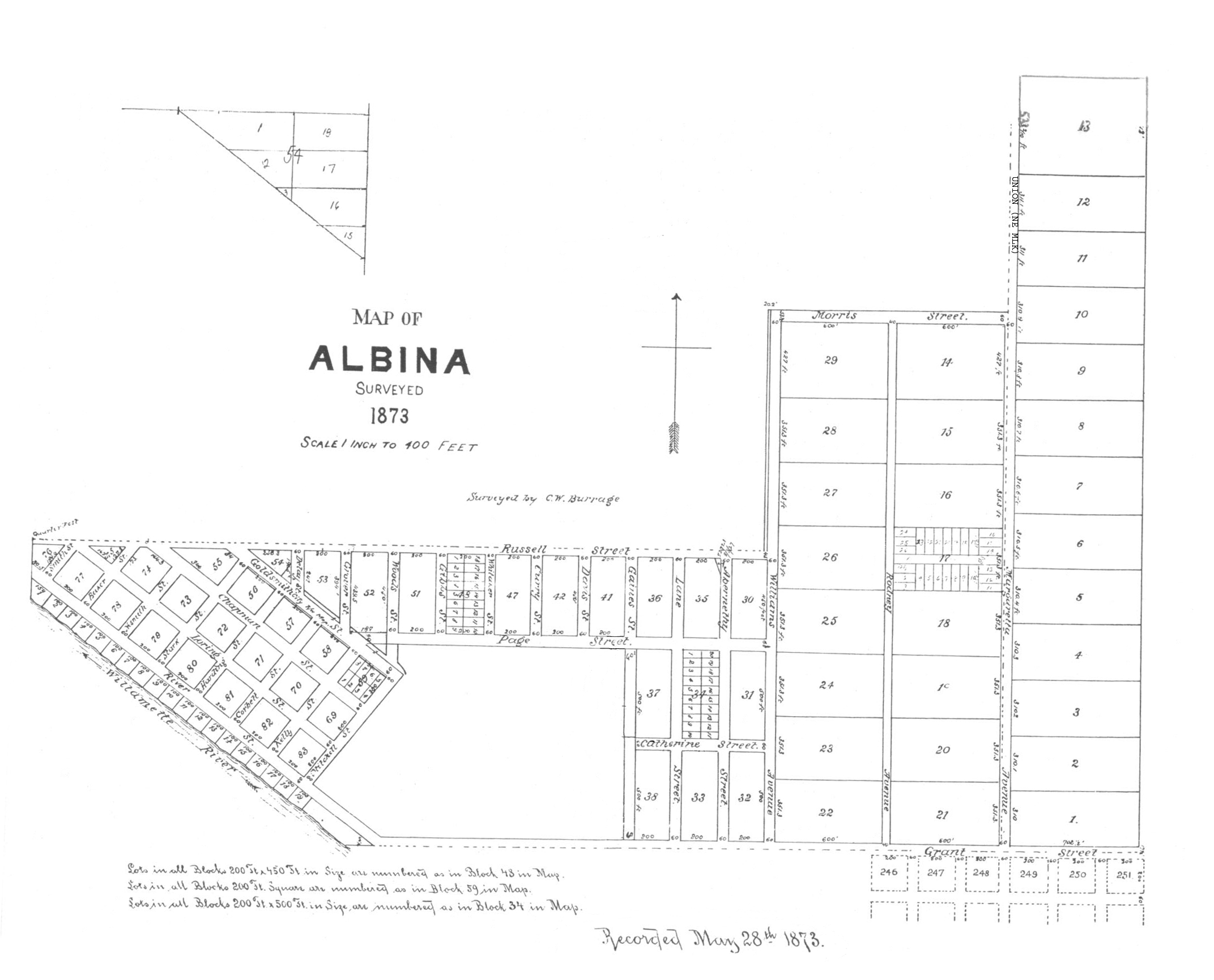
The original Town of Albina was named for Albina V. Page {pronounced al-BEEN-a) , the wife of William W. Page, one of the owners of the townsite. George H. Williams, another owner, platted and laid out the town in 1873. The original plat, which is now entirely inside the present Eliot neighborhood, was generally bounded by the Willamette River to the west, Hancock Street to the south, and Northeast 7th to the east. On the north side, Northeast Ivy was the limit between today’s Northeast Martin Luther King Boulevard (MLK) and 7th, Northeast Morris between North Williams Avenue and MLK, and North Russell from the railroad tracks to North Williams.
In the early 1870s, railroad magnate Ben Holladay began building a railroad from the east side of the Willamette to Sacramento, California. The plan, with a transcontinental link, included a large terminal next to Albina, with large docks at the river and maintenance shop facilities. In 1874, deep recession set in, and Holladay went broke, leaving the railroad unfinished and creating a dramatic slowdown in the developing town. Soon, Edwin Russell, the primary developer for the town, was also bankrupt.
In 1879, developers William Reid and James B. Montgomery, also with ties to transportation, purchased most of Albina and established a new industrial infrastructure, which was strengthened when the transcontinental railroad link was completed in 1883. People found work in the railroad shops terminal, on the docks, and with other industrial operations that opened up. Many small businesses were established, and construction boomed with new buildings and homes.
European immigrants, especially Irish, Germans, and Scandinavians, found jobs in Albina, and they were soon arranging for their families, relatives, and friends to locate in the growing town. Many of the transplants from Germany, Norway, Sweden, Denmark, and Finland had carpentry skills that had been passed down through generations, and some of the smaller homes they built still stand in residential pockets throughout the Albina community.
When Albina was incorporated in 1887, the city included subdivisions that were well outside the original townsite, and strong efforts were made to manage growth. In 1889, several streetcar lines connected parts of the city, including one that operated along the North Portland peninsula to St. Johns. The city expanded its boundaries several times, including into sparsely settled areas near today's Columbia Boulevard.
After the City of Albina was consolidated with the City of Portland in July 1891, the area continued to grow and fill in. This was even the case during the 1893 depression, which was harsh on Portland, as lumbering, manufacturing, and shipping were drastically scaled back. By 1900, the local economy had turned around and Portland entered a building boom after the successful 1905 Lewis and Clark Centennial Exposition. Through 1912, there was a frenzy of building activity and an expansion of manufacturing and railroad operations. Streetcar lines crisscrossed the Albina area as the population increased.
After 1910, African Americans who had been crowded into the lower section of Northwest Portland began to trickle into the lower Albina area along North Russell Street west of Williams Avenue and also along lower North Broadway near today’s Memorial Coliseum and Rose Quarter. Most of this second area was originally platted as McMillen's Addition, part of East Portland, and was loosely called Lower Albina.
African Americans gradually migrated north and east, filling voids in the neighborhoods previously occupied by European transplants, some who moved to more affluent neighborhoods to the north and east. The housing in the Albina neighborhoods was affordable, the transportation system was good, and men could find jobs as railroad porters and in the railroad shops.
The African American community grew slowly in Albina until World War II, when a large influx of Black workers moved to Portland to fill jobs for the local war effort, most of them in the large shipbuilding yards on the Columbia and Willamette Rivers. The surge also created a housing shortage, especially for African Americans, who faced discrimination. In 1942, a large community housing development called Vanport was built in outer North Portland to house shipyard workers, many of whom were African Americans.
After the war, the shipyards closed, and a good portion of Black workers left Portland because of lack of work and unfair job discrimination. After the 1948 Columbia River flood, which destroyed the town of Vanport, African Americans were forced to settle in nearby North Portland communities, including most of the Albina area.
In the 1960s, Interstate 5 freeway construction cut a swath through the Eliot, Boise, and Humboldt neighborhoods, displacing many residents and local businesses. In 1969, the Model Cities Program was implemented for Albina in an effort to revitalize the area, but with limited success. During the 1970s, the Eliot Neighborhood suffered from Emanuel Hospital urban renewal expansions, creating worse economic blight in the area. Since the late 1980s, however, improved city planning has generally had a positive influence in rejuvenating the community while maintaining diversity.
-
![Albina plat map, 1873.]()
Albina area, plat map of, 1873.
Albina plat map, 1873. Courtesy Roy Roos
-
![]()
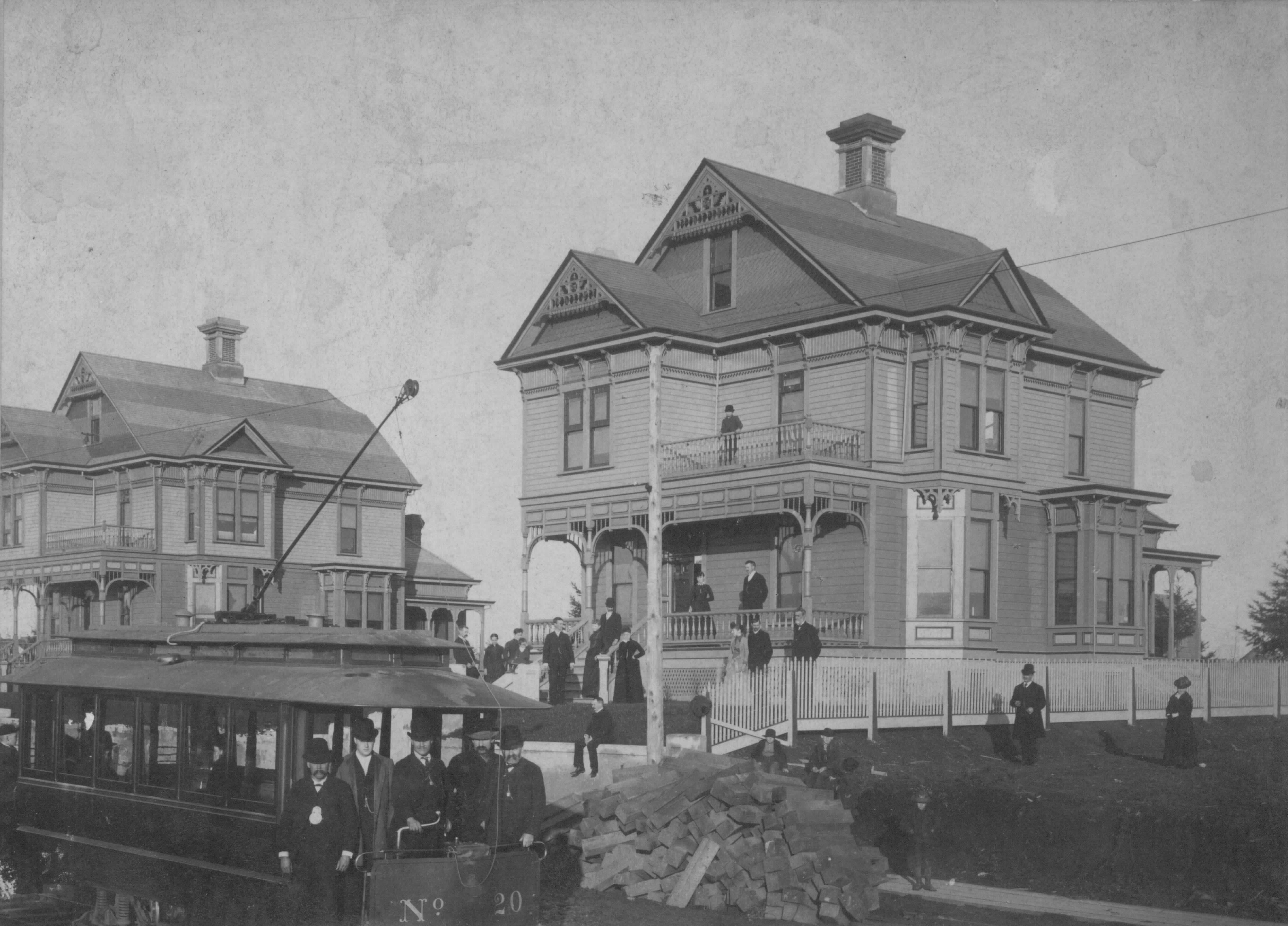
Residence at 2030 N Williams, in Portland's Albina area, 1889.
Courtesy Dorothy Thompson Smith
-
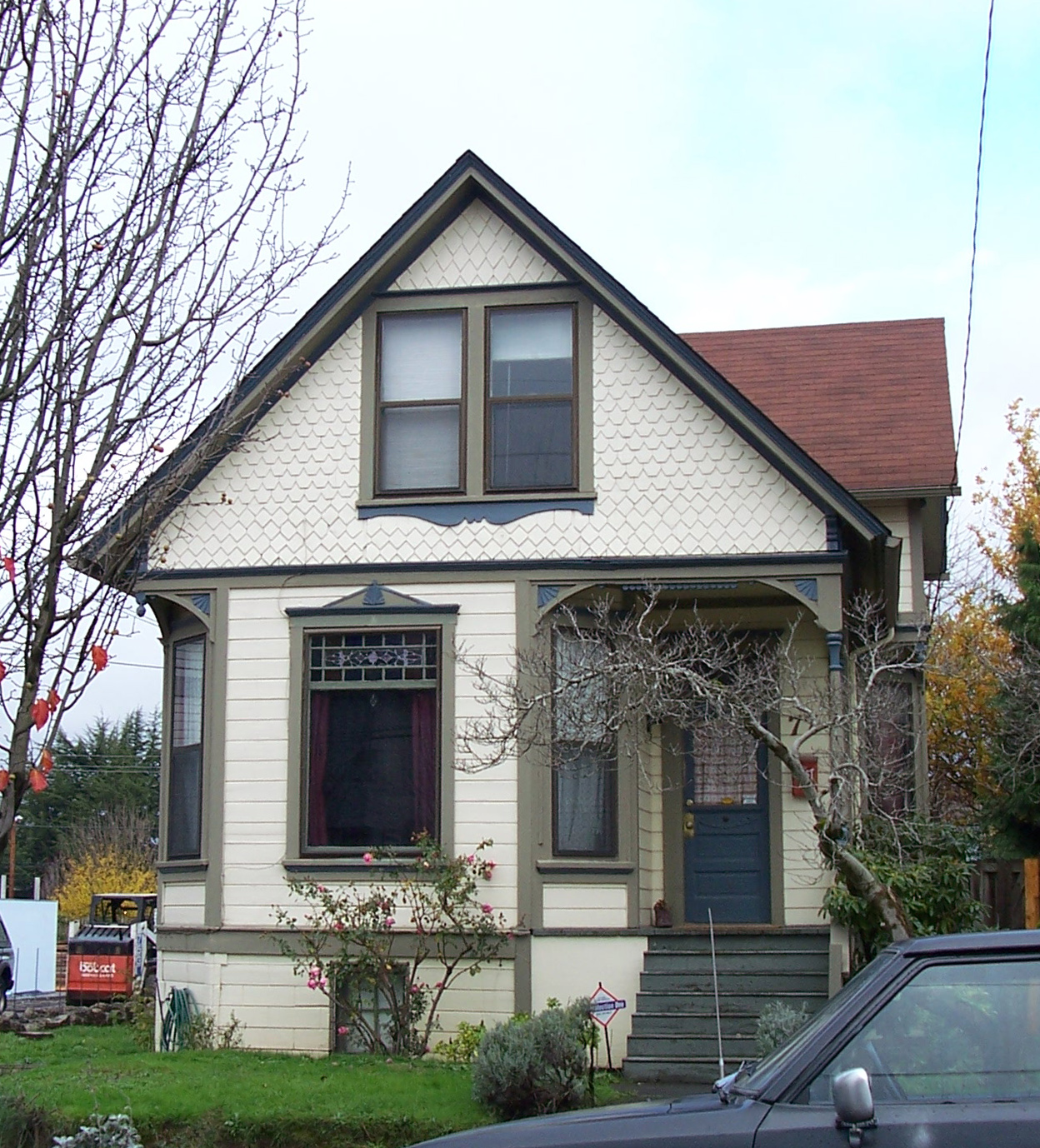
![Residence at 77 NE Graham, in Portland's Ablina area, 2006.]()
Albina Residence.
Residence at 77 NE Graham, in Portland's Ablina area, 2006. Copyright Roy Roos
-
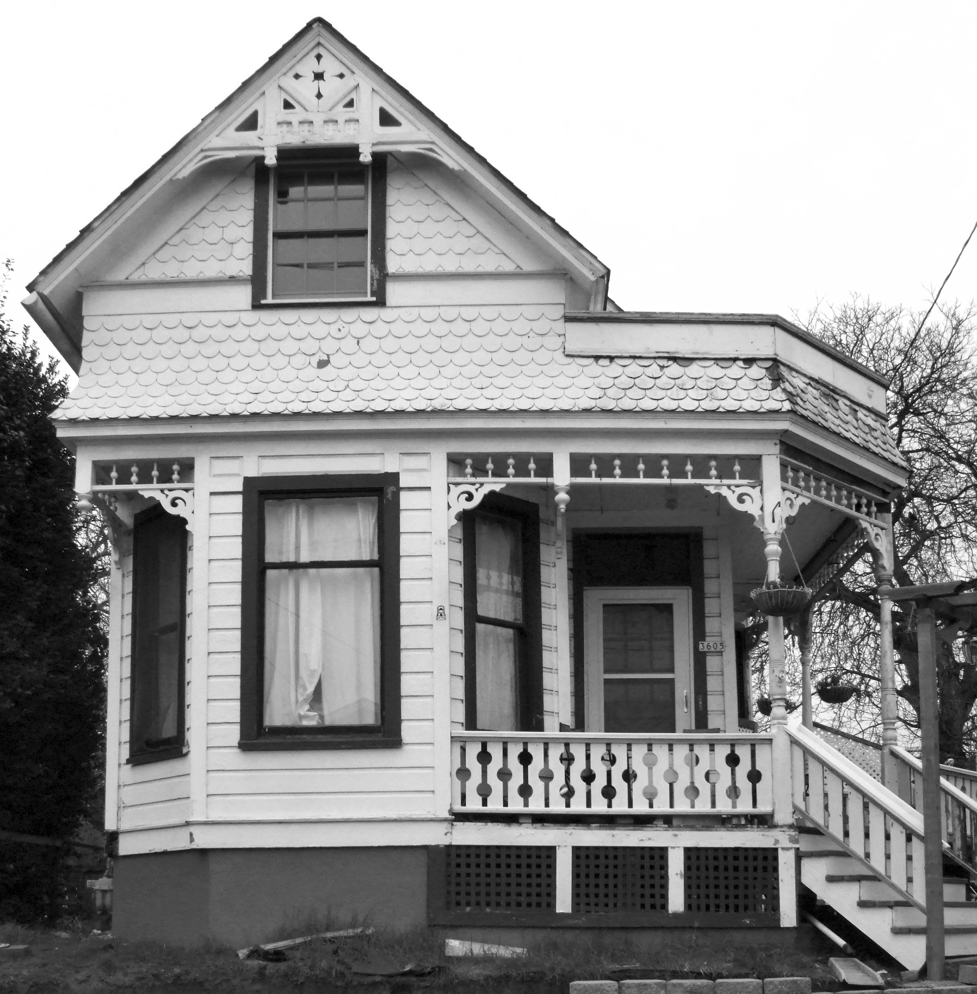
![Residence at 3605 N Albina, in Portland's Ablina area (built 1890), 2007.]()
Albina area, 3605 N Albina, 2007.
Residence at 3605 N Albina, in Portland's Ablina area (built 1890), 2007. Copyright Roy Roos
Related Entries
-
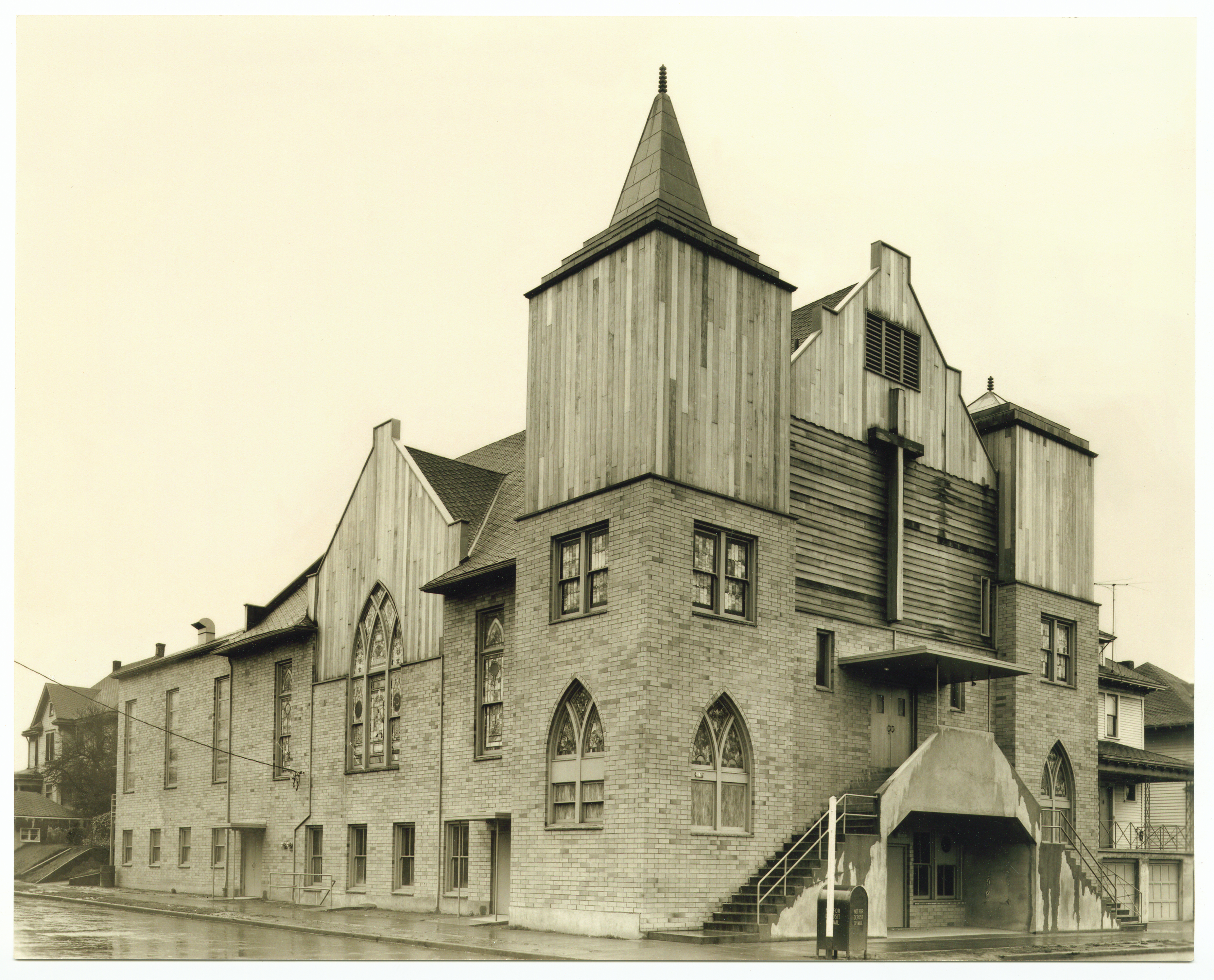
![First African Methodist Episcopal Zion Church]()
First African Methodist Episcopal Zion Church
First African Methodist Episcopal Zion is Portland's oldest African Ame…
-
![Interstate 5 in Oregon]()
Interstate 5 in Oregon
Interstate 5 is a 308-mile-long segment of highway that runs between th…
-
![Portland]()
Portland
Portland, with a 2020 population of 652,503 within its city limits and …
-
![Portland streetcar system]()
Portland streetcar system
The majority of Portland’s oldest neighborhoods owe their location and …
-
![Vancouver Avenue First Baptist Church]()
Vancouver Avenue First Baptist Church
The history of the Vancouver Avenue First Baptist Church of Portland is…
-
![Volga Germans in Oregon]()
Volga Germans in Oregon
The first group of Volga Germans arrived in Oregon in 1881, encouraged …
Map This on the Oregon History WayFinder
The Oregon History Wayfinder is an interactive map that identifies significant places, people, and events in Oregon history.
Further Reading
Roos, Roy E. The History of Albina. Portland, OR: Roy Roos, 2008.