A standard dictionary definition for drought is “a prolonged period of abnormally low rainfall, leading to a shortage of water.” From a societal perspective, however, drought occurs when there is “insufficient water to meet needs,” as described by Kelly Redmond, State Climatologist of Oregon and director of the Western Regional Climate Center. Water falling as rain or snow fulfills a wide range of needs. That water is important for fisheries and other ecosystems, and also for agriculture, urban and rural communities, hydroelectric power generation, and year-round recreation.
The definitions of drought are used to characterize how much water is available to meet those needs. They focus on water supply, water demand, or both and are usually categorized on the basis of duration and severity. Duration refers to how long below-average precipitation lasts, and severity reflects the intensity, or magnitude, of dry conditions.
Types of Drought
The American Meteorological Society defines four types of drought:
Meteorological droughts are based on the magnitude of below average rainfall, below average snowfall, or both (known as precipitation deficit) or on a thirstier atmosphere (called excessive evaporative demand).
Agricultural droughts occur when the characteristics of meteorological drought are defined by how they affect the supply and demand of water for agricultural needs, including how dry the soils are (soil moisture deficits) and how row crops, orchards, pastures, and rangelands in irrigated and dryland settings are affected.
Hydrological droughts occur when the water supply is low and affect conditions in surface water and groundwater. These droughts tend to arise when there is less precipitation than average, more evaporative demand than average, or both. Hydrological droughts tend to follow one or more years of meteorological droughts, and they usually precede agricultural droughts.
Socioeconomic droughts are the result of imbalances in the supply and demand of water-related commodities and services. This kind of drought encompasses broader impacts on human communities, including decreases in economic activity as agriculture, industry, and tourism decline. Social impacts extend beyond monetary losses and include effects on mental and physical health.
Evaluating Drought
Drought evaluation considers how droughts influence activities or ecosystems and the extent of the areas affected. Observing and monitoring droughts are important parts of that evaluation. Droughts are monitored by using data from weather stations, human observers, satellites, and computer modeling. Data are gathered from streamflow, snowpack, groundwater and reservoir levels, soil moisture, plant conditions, animal behavior, and climate variables such as temperature, precipitation, and evapotranspiration (that is, water transpired by plants or evaporated from soil or bodies of water).
One common drought indicator is the standardized precipitation-evapotranspiration index, or SPEI (see Figure 1 in documents below), which relies on data from both the supply and demand sides of drought. Year-to-year variations of drought conditions have been observed in Oregon since 1895. The driest single year was in 1977; the wettest was in 1983. Longer droughts occurred during the 1920s–1930s and the 1980s–1990s. Multiple moderately to extremely wet years, called pluvials, took place during the early 1980s and late 1990s. While environmental data informing drought conditions have changed over the years, temperature and precipitation were the key elements used during the early years of recordkeeping.
Because drought conditions vary across Oregon (see Figure 3 in documents below), using as many natural drought indicators as possible helps scientists place current or recent droughts in a long-term context. In Oregon, for example, trees respond to drought in surprising ways, and scientists have been able to use them to identify dry and wet periods across time. Tree growth at high elevations is usually limited by deep snowpacks, such as those on Mount Hood. When precipitation is near normal but snowfall is below normal, creating what is known as a warm snow drought, the trees take advantage of the longer snowfree season and grow wider rings. Trees at lower elevations in dry climates, such as in the rain shadow of the Cascade Range, are sensitive to the total amount of precipitation. Additional moisture in those trees encourages thicker rings. When trees in both forests have narrow rings, then it is likely that conditions were drier but cooler.
The National Integrated Drought Information System coordinates Drought Early Warning Networks, and the Oregon State Climate Office and local National Weather Service provide frequent updates through social media and websites. In order to classify how severe a drought is, the U.S. Drought Monitor uses a ranking system based on monitoring data and discussions with the public. Drought classifications can be used to support emergency declarations or to encourage the public to engage in water-saving measures. They are also helpful for comparing conditions, both in Oregon and across the country.
Drought monitor rankings range from Drought Category 0 (D0), which means conditions are abnormally dry, to D4, which identifies an exceptional drought. Because the need for water varies from the windward (coastal) to the leeward (desert) sides of the Cascade Range and in watersheds like the Willamette River, drought category ratings must reflect the local impacts of water deficits. A December precipitation value of one inch below normal as a percentage of total annual rainfall, for example, has a very different effect on people living near the coast in Florence or Eugene than it does in Burns in the High Desert or at the base of Mount Bachelor in central Oregon.
Drought in Oregon
At the state level, drought conditions can be grouped to show how much of Oregon is in each drought category (see Figure 2 in documents below). General conditions in the state, however, may not accurately reflect local conditions. Oregon is a large state with many climate regions and water sources, and environmental conditions can vary widely from north to south or on either side of the Cascades, leading to variance in drought declarations and mitigation measures.
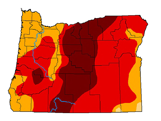
Drought monitor maps (Figure 3) illustrate how drought varies across Oregon. In 2003, for example, drought was widespread and was especially severe in the southeastern part of the state, but it did not impact northwestern Oregon. In late 2019, northwestern Oregon experienced moderate drought while the majority of the state had no drought conditions. In 2020 and 2021, the state experienced its most severe drought since 2000, which contributed to tree die-offs, low reservoir levels, reductions in crop yields, stressed wildlife, and dry vegetation that was susceptible to wildfire. In 2021, drought occurred throughout the state, with large areas suffering from extreme to exceptional drought. After a wet winter, there were major improvements in conditions, and many areas, mostly west of the Cascade Range crest, became drought-free. Nevertheless, exceptional drought persisted in Crook and Jefferson Counties.
Oregon mountains are natural reservoirs for towns and cities and for ecosystems. Winter snowfall melts and runs off during the spring and summer, allowing water to meet needs during drier months. But Oregon mountains are prone to drought, and it is common for the state to experience droughts caused by less than average precipitation, which leads to below normal snowfall. Even with near normal or even above normal precipitation, there is growing concern by climate scientists that warmer than normal winter temperatures will result in rain instead of snow. Under those conditions, runoff from precipitation is available in the spring, not in the summer and early autumn. The wet, warm winter of 2014–2015 epitomized warm snow drought conditions. Little to no snowpack accumulated that winter, despite above normal precipitation. In contrast, when below average precipitation causes below average snowfall, warm snow droughts occur when sufficient precipitation falls as rain, not snow.
The natural variability of climate and human dependence on water have raised concerns for the future. Projections of Oregon climate for the 2050s–2080s indicate not just a warmer future but one with longer and more severe droughts. Higher temperatures and a drier atmosphere (through lower humidity) increase evapotranspiration, which in turn lowers soil and vegetation moisture and stresses vegetation. Those effects increase the hazard of wildfire and produce unhealthy ecosystems. Several successive years of dry conditions increase the chances of drought, and years of wet conditions increase the chances of flooding.
Society is not prepared for conditions of low to no snow, and Oregon’s snowpacks, especially at lower and middle elevations, are at risk because of global warming. Loss of snowpack changes the hydrologic cycle, which makes water management more difficult because of changes in the timing of stream and river flows needed for irrigation, urban use, hydropower, and recreation. Also, less stream flow means warmer water temperatures and an unhealthy environment for fish and other aquatic species. Climate cannot be controlled, and addressing Oregon’s risk to a drought-prone and wildfire-prone future requires collaborative efforts that increase water supply options, reduce demand, and encourage flexibility in how water is managed.
-
![]()
Map of U.S. Drought Monitor categories, 2021.
Courtesy Benjamin Hatchett
-
![]()
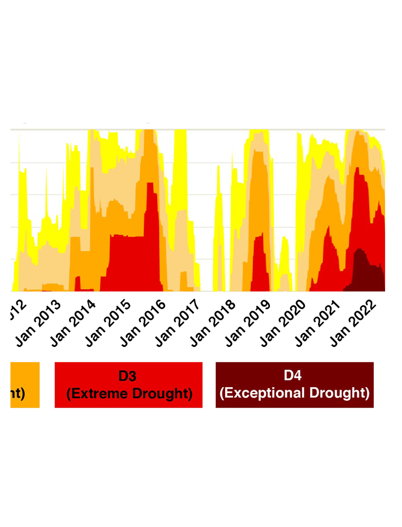
Percent Area in Drought (cropped).
Courtesy Benjamin Hatchett
Documents
Related Entries
-
![Climate Change and the History of Energy in Oregon]()
Climate Change and the History of Energy in Oregon
Unlike in other parts of the country, hydropower is the largest source …
-
![Climate Change in Oregon]()
Climate Change in Oregon
Within a few hundred miles in Oregon, you can see snowy volcanoes, parc…
-
![Glaciers in Oregon]()
Glaciers in Oregon
Glaciers and permanent snowfields—found in many western states, includi…
-
![Oregon Climate Change Research Institute]()
Oregon Climate Change Research Institute
The Oregon Climate Change Research Institute was established in 2007 to…
-
![Oregon Forests and Climate Change]()
Oregon Forests and Climate Change
How climate change affects Oregon forests and how those forests affect …

Map This on the Oregon History WayFinder
The Oregon History Wayfinder is an interactive map that identifies significant places, people, and events in Oregon history.
Further Reading
Redmond, K. "The Depiction of Drought: A Commentary." Bulletin of the American Meteorological Society 83.8 (2022): 1143-1147.
Siirila-Woodburn et al. "A low-to-no snow future and its impacts on water resources in the western United States." Nature Reviews Earth and Environment 2 (2021): 800-819.