The U.S. Army Corps of Engineers, a hybrid military and civilian federal agency, developed Oregon's water transportation infrastructure and played a major role in the state's economic growth. Beginning in the 1820s, Congress mandated the Corps to improve the nation's navigable rivers and harbors so they could safely accommodate ever-larger vessels. In late nineteenth-century Oregon, the Corps' Portland Engineer Office carried out that mission by constructing jetties at coastal harbors and the mouth of the Columbia River and deepening river channels on the Columbia and Willamette Rivers.
In the twentieth century, the Portland Office (now called the Portland District) moved from single-purpose navigation projects to large-scale, multiple-purpose water resources development within large river basins, involving navigation, hydropower, flood control, and irrigation. The Corps conducted comprehensive river basin surveys, which led to the construction of major dams on the Columbia and Willamette Rivers and their tributaries. During the second half of the twentieth century, the Corps increasingly took into account environmental concerns as it planned, constructed, and maintained water resources projects.
Oregon's early growth depended on the use of its major rivers, which carried steamboats that transported the agricultural and mineral production from eastern Oregon and the Willamette Valley to Portland. In return, the outlying areas of Oregon received finished goods and farming and mining equipment. From Portland, ocean-going vessels carried the raw materials to markets in the eastern United States and overseas. While the arrival of the transcontinental railroads in the 1880s reduced the state's dependence on water routes, the Columbia and Willamette Rivers remained useful and economical for shipping bulk cargoes, including grain, logs, wool, and, later, petroleum. River transportation, moreover, provided competition to the railroads and helped hold down freight rates.
In their natural state, the Columbia and Willamette Rivers presented obstacles to easy navigation for steamboats and deeper draft vessels. Rapids, rocky reefs, and shoals encumbered the Columbia; and snags, shifting channels, and heavy sedimentation caused by annual freshets clogged the Willamette. Overcoming these impediments was technically difficult and expensive, requiring the expertise and financial support of the federal government. Responding to local lobbying and the efforts of the state's congressional delegation, Congress authorized navigation improvements and in 1871 established a Corps engineer office in Portland.
The Corps began its water resources work in Oregon by improving the ship channel between Portland and the mouth of the Columbia. Starting in 1868, even before establishing its office in Portland, the Corps undertook to deepen the 110-mile ship channel. By 1875, the Corps had dredged a 17-foot-deep navigation channel, which supported almost 185,000 tons of shipping, chiefly wheat and lumber. Over the next twenty years, Congress funded Corps projects to increase the ship channel depth to accommodate ever-larger ships, until by the mid-1890s the channel was 23 feet deep and total cargo tonnage averaged over 1.4 million tons a year.
During the same period, the Corps began improving the navigability of the Columbia River between Portland and Lewiston, Idaho. The mining rushes of the 1860s and the growth of wheat farming on the Columbia Plateau in the 1870s and 1880s stimulated the expansion of steamboat shipping on the Columbia and Snake Rivers. The Oregon Steam Navigation (OSN) transportation monopoly, owned by Portland merchants, dominated the commercial traffic on the rivers.
Working through Oregon's congressional delegation, Portland business interests secured congressional authorization and funding for the Corps to improve the river's navigability. Between 1872 and 1892, the Corps completed a five-to-six-foot navigation channel from Portland to Lewiston and labored on a major project to construct a canal and locks at the Cascades of the Columbia, one of the two major impediments to open river passage. The blockage occurred in the rapids between The Dalles and Celilo Falls. In the Columbia River's natural state, costly portages were required at both the Cascades and The Dalles-Celilo Falls. After twenty years of arduous effort and the expenditure of almost $4 million, the Corps opened the Cascades Canal to steamboats in 1896. The Corps completed its open river work by constructing The Dalles-Celilo Canal between 1905 and 1915.
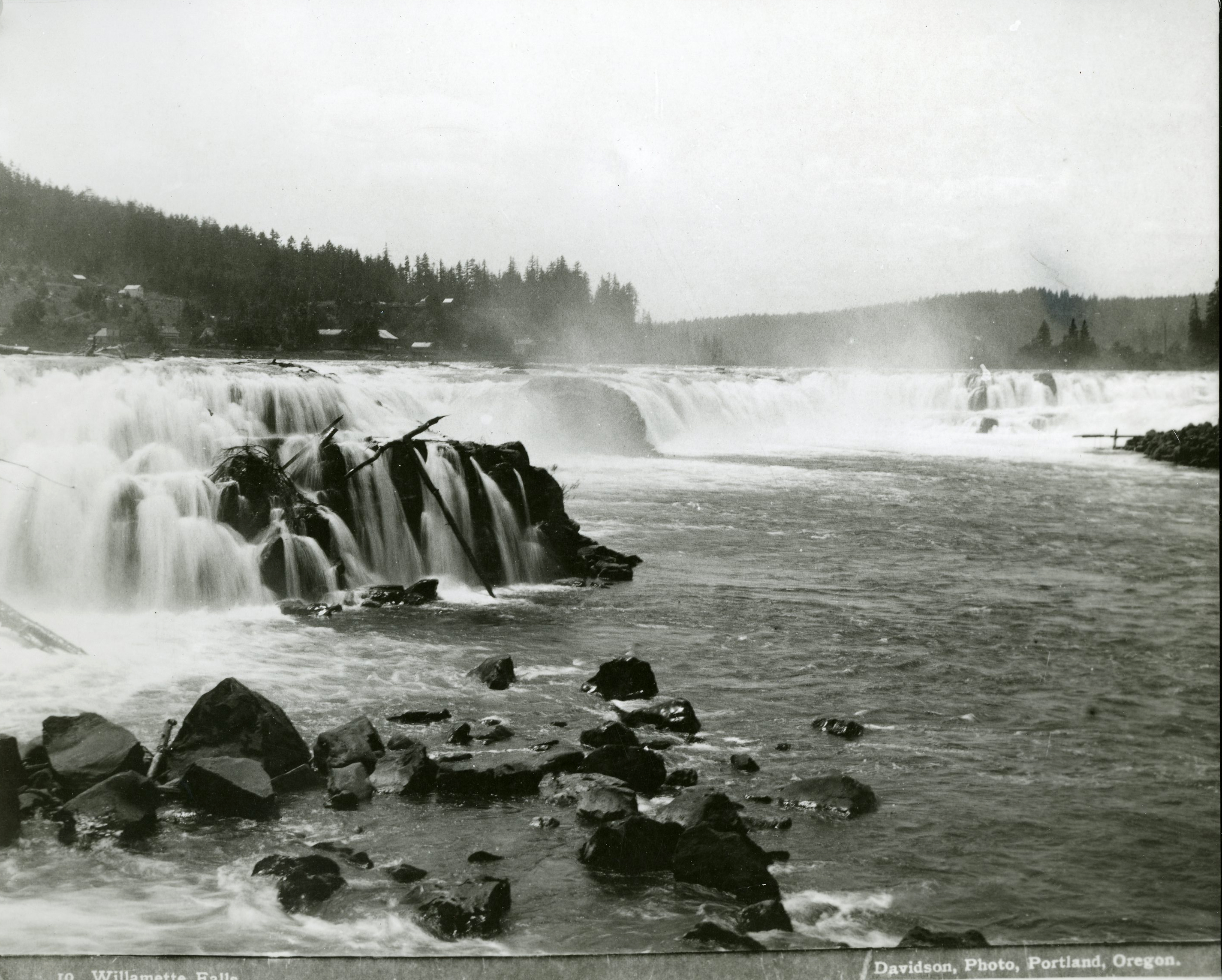
Starting in 1871, Corps engineers also carried out navigation projects on the Willamette River, snagging, dredging, removing rock, and constructing current-deflection devices, such as wing dams and pile dikes. By 1900, the Corps had expended $448,500 on establishing and maintaining a shallow-draft steamboat channel as far upriver as Eugene. This improvement, together with the construction of the Willamette Falls Canal and Locks (1873) by private interests, provided Willamette Valley farmers with inexpensive and efficient transportation for their produce to Portland until railroads operated regularly in the valley.
To improve the dangerous conditions at the mouth of the Columbia River, Portland and Astoria business interests persuaded Congress to authorize a massive jetty to establish a deep and stable ship channel across the bar. After careful study, the Corps recommended in 1882 a 10,000-foot rubblestone jetty to achieve a 30-foot channel depth. When completed in 1895, the jetty project had cost about $2 million. Still, the Corps found it difficult to maintain a dependable channel and in 1913 undertook a project to add a north jetty, which would provide a 40-foot channel over the bar. When completed in 1917, the two jetties, with 9 million tons of stone, were the largest in the world.
To accommodate ever-larger ocean-going vessels, Congress periodically authorized the Corps to deepen the ship channel from Portland and rehabilitate the jetty at the mouth of the Columbia. By the 1970s, the Corps' jetty and dredging operations had established and maintained a depth of 48 feet over the bar and a ship channel of 40 feet to Portland. Between 1871 and 1976, annual tonnage of shipping over the Portland-to-the-sea ship channel increased from 147,000 to 42 million tons. In the early twenty-first century, Congress authorized the Corps to increase the ship channel to 43 feet, a project that requires significant environmental mitigation to compensate for effects on wetlands habitat and endangered salmon.
Economic interests along the Oregon coast also lobbied for navigation projects to improve harbors. During the late nineteenth century, rail service and roads were almost nonexistent, and water transportation was the most economical way to develop the region's timber and fishing resources. The Corps recommended building a jetty at Coos Bay to increase the depth and stabilize the channel for the most important lumber port on the Oregon Coast. As work began on this project in 1879, the Corps also began building a jetty at the mouth of the Coquille River in southwestern Oregon.
A third project required building a jetty at Yaquina Bay in Newport, starting in 1881, which served commerce arriving by rail from the upper Willamette Valley. Between 1890 and 1920, the Corps also accomplished navigation improvements on the lower Umpqua River near Reedsport and built jetties at the mouth of the Siuslaw River at Florence, the Nehalem River, and at Tillamook Bay. The Corps used novel engineering and construction techniques to overcome hazardous conditions of site and currents at these coastal jetty projects. Maintenance of the completed jetties also proved a constant and expensive process, as the incessant pounding of ocean waves and winter storms took their toll on the stone structures. The Oregon coastal projects, costing $4.7 million by 1920, encouraged the gradual growth of the region's commerce.
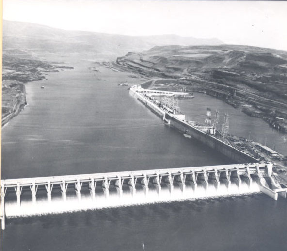
During the 1920s, the Corps moved from single-purpose water resources projects to multipurpose water development. Congress directed the Corps to conduct a series of comprehensive river basin surveys across the nation for the combined development of hydropower, flood control, navigation, and irrigation. The Columbia River and its tributaries fell under this study; and the resulting "308 Report," completed in 1931, served as the basic planning guide for federal multipurpose water resources projects undertaken in the Pacific Northwest. Beginning with Bonneville Dam in the 1937, the Corps constructed McNary (1954), The Dalles (1957), and John Day (1971) dams.
The economic impact of these dams on Oregon has been enormous. The inexpensive hydroelectric power produced by the dams encouraged the development of the state's aluminum and high-technology industries and led to rural electrification. Navigation locks at each dam created a slackwater transportation system that brought the grain of the Inland Empire to Portland for worldwide distribution and provided petroleum products to consumers in the interior. The system of Columbia River and tributaries dams provided flood control and water for irrigating portions of the Columbia Basin, helping develop the agricultural potential of the Pacific Northwest. Above all, the inexpensive power produced by the dams in the late twentieth century helped fuel the effort to diversify economic development in Oregon as the timber industry began to falter.
The Willamette River continued to pose navigation and flood-control problems for agricultural interests and developers, and during the 1930s the Corps produced a comprehensive plan for using the basin's water resources. The plan called for constructing seven reservoirs to provide flood control, navigation, irrigation, power generation, and pollution control within the 3,456 square miles of Willamette River drainage. Although Congress authorized the Willamette Valley project in 1938 and work began on three dams prior to 1941, World War II delayed its completion. Ultimately, the Corps constructed eleven storage and two re-regulating dams to provide 1.7 million acre-feet of flood control storage and 408,000 kilowatts of power. The dams not only provided significant flood damage reduction and electrical power, but they also greatly improved water quality and stream flow for the Willamette basin's fishery.
In the second half of the twentieth century, the Corps has played a role in the environmental health of Oregon's navigable waterways and since the 1930s has responded to the environmental effects of its projects. Despite the charges of its critics, the Corps, in preparing the "308 Report," took into account the impact of the proposed dams on the anadromous fishery. Corps engineers and fishery experts devised fish passage facilities for Bonneville Dam, for example, that served as prototypes for other dams on the Columbia and Snake Rivers.
Unfortunately, the cumulative impacts from degraded habitat and passage losses have continued to challenge the Corps' fish conservation and mitigation program for Oregon's navigable rivers. Increasingly since the 1970s and the passage of the Clean Water Act in 1972, the Corps has developed nonstructural responses to flood-control problems and shoreline erosion—such as restoring wetlands, restricting development of flood plains, and conditioning permits for in-water work—and has integrated environmental concerns into its planning, construction, and operations in Oregon.
For almost 150 years, the Army Corps of Engineers carried out water resources projects that enabled the economic development of Oregon. Initially, the projects focused on navigation improvements for the state's rivers and harbors. In the twentieth century, the Corps' mission expanded to include multipurpose work in Oregon, providing hydropower and flood control for the state. In response to public concerns about the environmental impacts of its projects, over time the Corps has responded by altering the way it carries out it water resources mission.
-
![]()
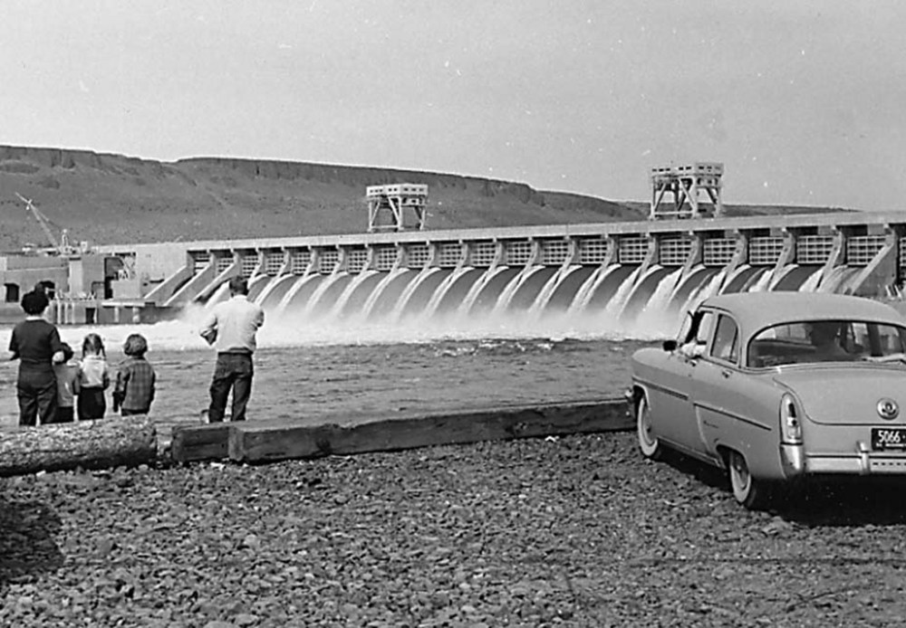
McNary Dam on the Columbia River.
Oreg. Hist. Soc. Research Library
-
![]()
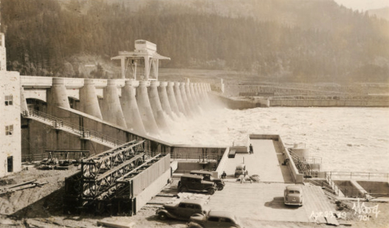
Bonneville Dam, 1936.
Courtesy Oregon Hist. Soc. Research Lib., 002652
Related Entries
-
![Bonneville Dam]()
Bonneville Dam
The U.S. Army Corps of Engineers built and operated Bonneville Lock and…
-
![Columbia River]()
Columbia River
The River For more than ten millennia, the Columbia River has been the…
-
![The Dalles Dam]()
The Dalles Dam
The United States Army Corps of Engineers constructed The Dalles Dam be…
-
![Willamette Falls]()
Willamette Falls
The largest falls in Oregon and the second in the United States by volu…
-
![Willamette River]()
Willamette River
The Willamette River and its extensive drainage basin lie in the greate…
Related Historical Records
Map This on the Oregon History WayFinder
The Oregon History Wayfinder is an interactive map that identifies significant places, people, and events in Oregon history.
Further Reading
Jennings, Todd, Lisa Mighetto, and Jill Schnaiberg. Currents of Change: A History of the Portland District, U. S. Army Corps of Engineers, 1980-2000. Portland: Army Engineers District, Portland, 2003.
Mighetto, Lisa, and Wesley Ebel. Saving the Salmon: A History of the U. S. Army Corps of Engineers' Efforts to Protect Anadromous Fish on the Columbia and Snake Rivers. Portland, Ore.: Army Engineer Division, North Pacific, 1994.
Robbins, William G. Landscapes of Conflict: The Oregon Story, 1940-2000. Seattle: University of Washington Press, 2004.
Willingham, William F. "Engineering the Cascades Canal and Locks, 1876-1896." Oregon Historical Quarterly (Fall 1987): 229-57.
Willingham, William F. Army Engineers and the Development of Oregon. Washington, D.C.: GPO, 1983.