Hole in the Ground is a spectacular bowl-shaped volcanic crater located on the western edge of the Fort Rock Basin and at the southern margin of lavas from Newberry Volcano. In maximum dimension, the crater is a mile across, with a depth of over 500 feet. It is located two miles off Oregon Highway 31, twenty-four miles southeast of La Pine and eight miles west-northwest of Fort Rock in the northwest corner of Lake County. Twenty locations in Oregon carry the name Hole in the Ground—one is named The Hole in the Ground, and two are named simply Hole in Ground. Most are erosional basins and valleys (15), and some are small playas (5) or springs (2), but only Hole in the Ground in Lake County is a result of a volcanic eruption.
The view from atop the east rim is expansive and includes all of Fort Rock Valley and the south flank of Newberry Volcano. The floor of the crater is at an elevation of 4,340 feet, while the crater rim ranges in elevation from 4,685 feet on its west side to 4,855 feet on the east. The pre-eruption ground surface is exposed in the crater wall at about 4,650 feet. The distance from the east to the west rim is approximately 4,500 feet and approximately 5,300 feet from north to south.
Because Hole in the Ground resembles Meteor Crater, a meteor impact site near Winslow, Arizona, geologists once thought it was the result of a similar collision. In 1961, geologists Norm Peterson and Ed Groh published the first paper on Hole in the Ground, describing its volcanic origin. They also published a guidebook for the Lunar Geological Field Conference in Bend in August 1965. In July 1966, NASA astronauts and scientists visited Oregon on an Apollo training session that included a stop on the rim of Hole in the Ground. At the time, central Oregon’s volcanic landscape was believed to be similar to the moon topography. NASA financed a four-part study of volcanic depressions, including one on the origin of Hole in the Ground, that included geology, geophysical studies, and drilling on the crater floor. The study confirmed that Hole in the Ground was a maar (a shallow crater made by explosive eruptions) formed as a result of hydrovolcanism. Volker Lorenz, a German geologist visiting at the Center for Volcanology at the University of Oregon, led the study.
Hydrovolcanism involves the interaction of rising magma with ground water or surface water. Without the water, the rising magma would have reached the surface and built a cinder cone, but the interaction with abundant water created violent steam-driven explosions. Hydrovolcanic landforms span a complete gradation from maar craters to tuff rings to tuff cones, depending on the depth of explosions and water content of the eruptive column.
In the case of Hole in the Ground, Lorenz concluded that the crater originated from a series of four major explosive events as basaltic magma rose and came into contact with abundant ground water at 1,000 to 1,600 feet below the surface. Following the initial explosion, occasional collapse of the overly steep vent walls into the crater intermittently closed the vent. Then changes in the ground water supply and the accumulation of pressure below the crater led to the next vent-clearing explosion. Lorenz estimated that the eruption lasted a few days to a few weeks.
Because of the lack of erosion, Lorenz suggested that the eruption occurred between 13,500 and 18,000 years ago, which is consistent with a high stand (a high water level) of now-dry Fort Rock Lake, one of several large lakes in central and eastern Oregon associated with the Pleistocene, the last major glacial epoch. Fort Rock Lake was a prehistoric lake, and Hole in the Ground was above the lake level and would not have been eroded by the lake water. A high lake level and, therefore, a high ground water level was necessary for the maar eruption to occur, so the eruption could have occurred during a glacial period. More recent studies indicate an older age, perhaps coincident with an earlier glacial epoch, as indicated by the lava flows that lap against the crater rim-forming explosion deposits and have an age between 50,000 and 100,000 years.
Hole in the Ground is just one of many hydrovolcanic features in the extended Fort Rock Basin, including the larger, more complicated, but mostly hidden Big Hole (six miles to west), Moffitt Butte (fourteen miles to west), Flat Top (seven miles to northeast), Fort Rock (seven miles to east southeast), and Table Rock (twenty-three miles to southeast).
-
![]()
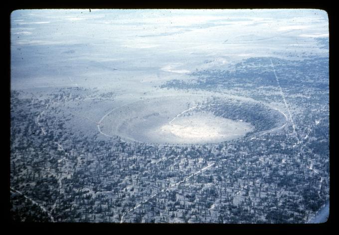
Hole in the Ground, Lake County, c.1970.
Courtesy Oregon State University Libraries -
![]()
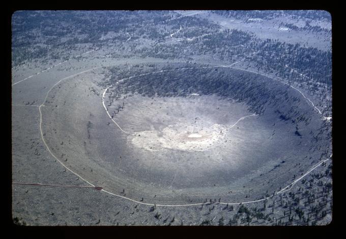
Hole in the Ground. c.1970.
Courtesy Oregon State University Libraries
Related Entries
-
![Crack in the Ground]()
Crack in the Ground
Crack in the Ground is just that, a gaping fracture of tectonic origin …
-
![Diamond Craters]()
Diamond Craters
Diamond Craters is a geologically youthful lava field 52 road miles sou…
-
![Fort Rock (formation)]()
Fort Rock (formation)
Fort Rock is a volcanic citadel at the western end of the Fort Rock Val…
-
![Jordan Craters]()
Jordan Craters
Jordan Craters is an otherworldly place, beautiful and foreboding, an o…
-
![Newberry National Volcanic Monument]()
Newberry National Volcanic Monument
Newberry Crater, as it is commonly known, is a large shield volcano eas…
Related Historical Records
Map This on the Oregon History WayFinder
The Oregon History Wayfinder is an interactive map that identifies significant places, people, and events in Oregon history.
Further Reading
Jensen, R.A. Roadside guide to the geology of Newberry volcano. 4th Ed.: Bend, Ore.: CenOreGeoPub, 2006.
Lorenz, V. "Some Aspects of the Eruption Mechanism of the Big Hole Maar, Central Oregon." Geological Society of America Bulletin (1970).
Lorenz, V. "An investigation of volcanic depressions. Part IV. Origin of Hole-in-the-Ground, a maar in central Oregon." NASA Progress Report, NGR-38-003-012 (1971).
Peterson, N.V., and Groh, E.A. "Hole-in-the-Ground, Central Oregon." The Ore Bin 23.10 (1961): 95-100.
Peterson, N.V., and Groh, E.A. "Maars of south-central Oregon." The Ore Bin 25.5 (1963): 73-88.