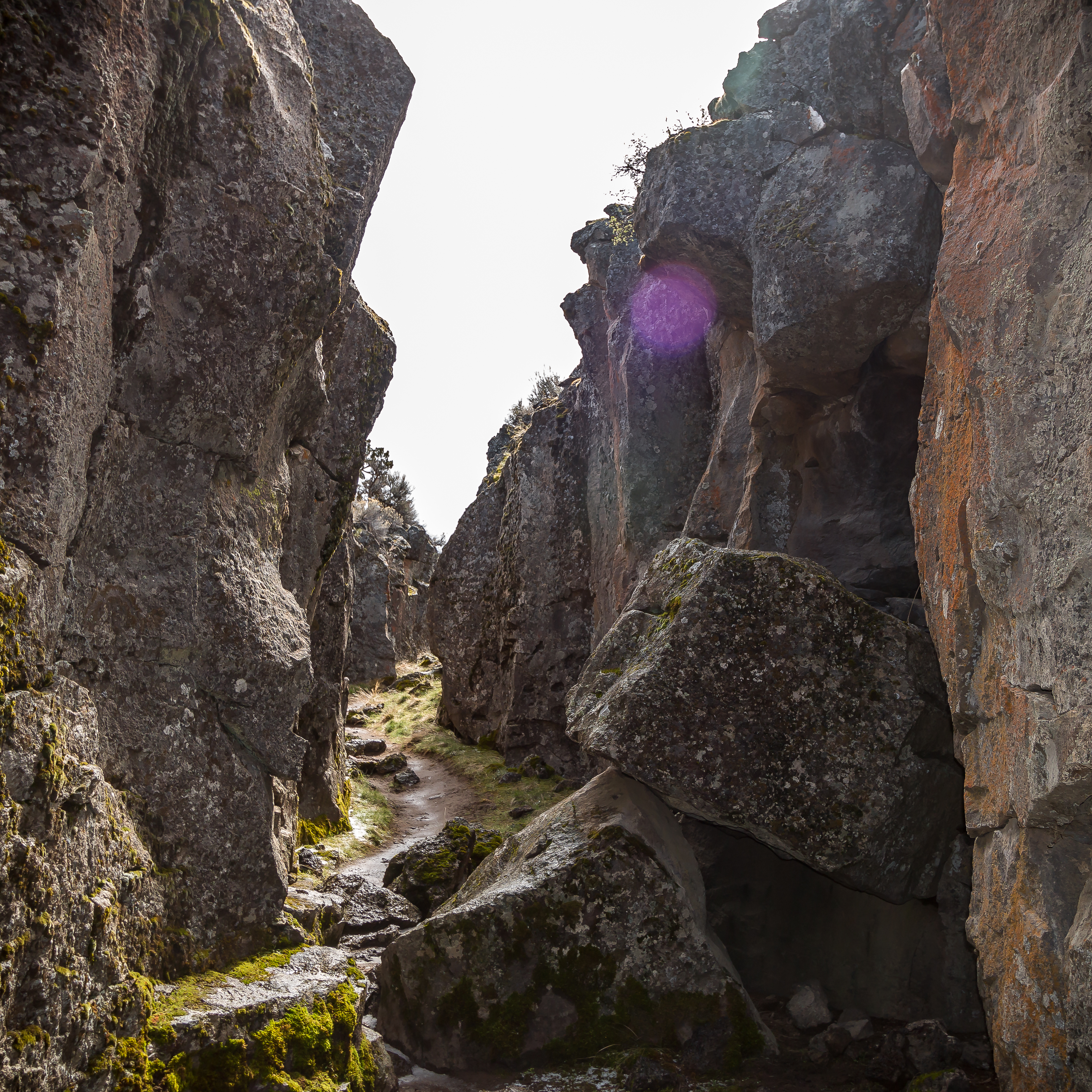
Crack in the Ground is just that, a gaping fracture of tectonic origin in the volcanic terrain of northern Lake County (pasting the coordinate pair 43.3325, -120.6711 in a mobile device map application will allow you to fly there). Long known as “the Crack” to local residents, it is located on the gently sloping upland north of Christmas Lake Valley, near the geographic center of the state.
Two miles long, Crack in the Ground was as deep as seventy feet in 2021. It once was deeper, before gradual infilling by a slight sidewall collapse and windblown sand. The crack is as wide as fifteen feet at the surface, but the gape may lie unseen in some places until nearly stumbled upon. The width along the floor inside the crack varies; where it is narrowest, a person can easily touch the adjacent walls with outstretched arms.
Crack in the Ground (43°19'57" N., 120°40'16" W.) is in the High Lava Plains geologic province, which encompasses an extensive swath of central and southeast Oregon. The province is noted for its abundant volcanoes, lava flows, and ash deposits, some of which are helpful for determining the Crack’s relative age. For example, the Crack must be younger than about 740,000 years ago, the time when the area was paved over by lava flows from nearby Green Mountain, a basaltic shield volcano. And the Crack must be older than about 14,000 years ago, because lava flows of that age from the Four Craters lava field, adjacent to the north, oozed over the existing edge of the Crack and southeastward along its floor for a few tens of feet. Trenches dug across the Crack’s floor, in search of additional evidence of age, have never reached deeper than about seven feet, bottoming in an ancient soil known only to be older than Mazama Ash—that is, older than 7,600 years.
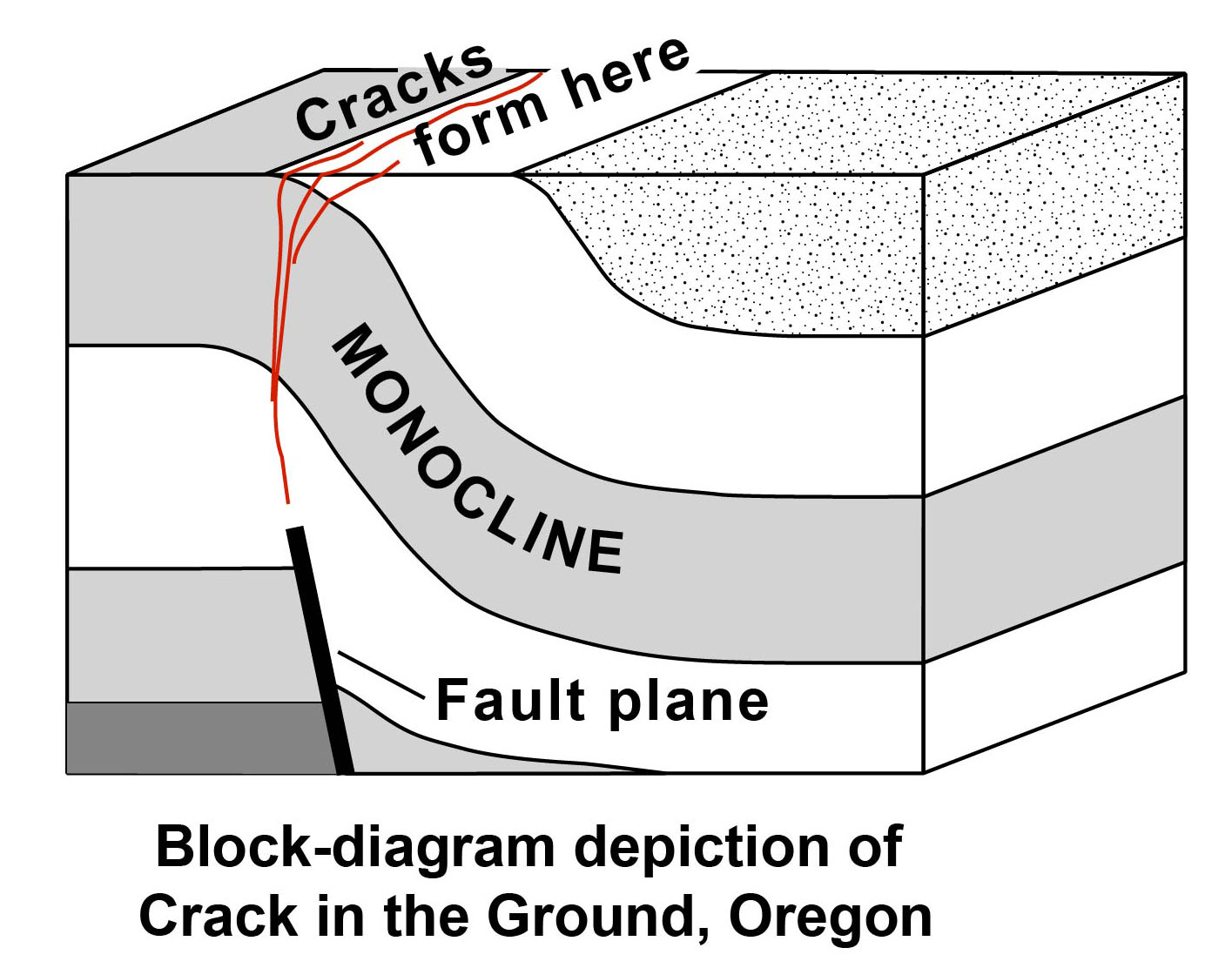
Earthquakes large enough to further disturb the ground since Four Craters time have been few, as shown by small cracks that perturb the Four Craters lava. Crack in the Ground marks the surface trace of an earthquake fault, the boundary that results when a block of the Earth’s crust is cracked in two. The fault’s northeast side is displaced down about thirty feet. At the Crack, however, instead of breaking to form a sharp escarpment, the layers of lava at the land’s surface flexed a bit as they were dragged downward in the process, draping across the fault to form a monocline of low relief (a monocline is a local steepening in stratified rocks whose layers are otherwise horizontal or only gently tilted).
The fault is one of several in the area. Offset along them is great enough to suggest deformation accumulated during many separate earthquakes. Given the history of tectonism in central Oregon, Crack in the Ground’s fault and neighboring faults likely have been sporadically active over millennia. They are the crustal response to earthquakes of magnitude 7 or larger, though such earthquakes in central Oregon have occurred rarely in the frame of human history.
But why a gaping crack? Flexing of the uppermost layers produced tensile (stretching) fractures parallel to the fault line. An analogy is the bending of a slightly softened sheet of wax, which at first folds but then cracks along the fold axis. Thus the fault and crack, so intimately related, have distinct qualities. The fault is a tightly closed shear fracture that penetrates much of the Earth’s upper crust, whereas the crack is a tensile fracture affecting only the uppermost few layers. The open crevice of Crack in the Ground is a shallow phenomenon, narrowing abruptly downward.
Although fault escarpments are common in the High Lava Plains, gaping cracks are rare. So what gives? The answer may lie simply in preservation, a testament to the geological youthfulness of Crack in the Ground. Future large earthquakes may obscure the crack by more deeply burying the downthrown side and shedding rockfall from the upthrown side. Windblown sand may eventually fill the Crack entirely.
Crack in the Ground predates human occupation, and its use by the Northern Paiute or other Indigenous people is unknown. As hunters, those people likely encountered the crack, and—like the picnicking homesteaders of Christmas Lake Valley who succeeded them—may have enjoyed the cool summer temperatures found in the deeply shaded bottom of the fissure (at times 20°F lower than at the surface).
The most common access, by vehicle, is by driving east a mile and a half beyond the town of Christmas Valley and turning north at the sign to Crack in the Ground. The road soon transitions to gravel and ascends from the valley to surrounding steppe. A parking area appears after about seven miles. From there a Bureau of Land Management footpath leads 0.3 mi east to the Crack.
-
![]()
Crack in the Ground.
Courtesy Bureau of Land Management -
![]()
Block-diagram, Crack in the Ground.
Courtesy Oregon Historical Society
Related Entries
Map This on the Oregon History WayFinder
The Oregon History Wayfinder is an interactive map that identifies significant places, people, and events in Oregon history.
Further Reading
Castonguay, S.R., Mackey, B.H., and Weldon, R.J., 2011, Paleoseismology of Crack-in-the-Ground fault, central Oregon [abs.]: American Geophysical Union Fall Meeting, Abstract T51B-2333, San Francisco, Calif., Dec. 5–9, 2011.
Jordan, B.T., Streck, M.J., and Grunder, A.L., 2002, Bimodal volcanism and tectonism of the High Lava Plains, Oregon, chapt. 2 of Moore, G.W., ed., Field guide to geologic processes in Cascadia: Oregon Department of Geology and Mineral Industries Special Paper 36, p. 23–46. https://www.oregongeology.org/pubs/sp/SP-36.pdf.
Mackey, B.H., Castonguay, S.R., Wallace, P.J., and Weldon, R.J., 2014, Synchronous late Pleistocene extensional faulting and basaltic volcanism at Four Craters lava field, central Oregon, USA: Geosphere; v. 10, no. 6, p. 1247–1254. doi:10.1130/GES00990.1.
Peterson, N.V., and Groh, E.A., 1964, Crack-in-the-Ground, Lake County, Oregon: Ore Bin, v. 26, no. 9, p. 158–166. https://www.oregongeology.org/pubs/og/OBv26n09.pdf.
U.S. Board on Geographic Names, 2020, https://www.usgs.gov/core-science-systems/ngp/board-on-geographic-names [accessed Dec. 6, 2020].
U.S. Geological Survey, 1983, Crack in the Ground, Oreg. (1:24,000 scale): https://prd-tnm.s3.amazonaws.com/StagedProducts/Maps/HistoricalTopo/PDF/OR/24000/OR_Crack-in-the-Ground_279483_1983_24000_geo.pdf [accessed May 29, 2021].
Walker, G.W., Peterson, N.V., and Greene, R.C., 1967, Reconnaissance geologic map of the east half of the Crescent quadrangle, Lake, Deschutes, and Crook Counties, Oregon: U.S. Geological Survey Miscellaneous Investigations Map I-457, scale 1:250,000.