During the Last Glacial Maximum, from about 24,000 to about 18,000 years ago, and for several thousand years thereafter, many pluvial (that is, rainfed) lakes filled the basins of southeastern Oregon. The majority of those lakes reached their deepest water levels—called highstands—in the last glacial cycle, shortly before 16,000 years ago. The closed basins of southeastern Oregon, also known as the Oregon Outback, is part of the Great Basin, a series of basins and mountain ranges where rivers and streams enter but don’t leave.
Each of these basins is much like a bathtub without a drain. If the faucet (precipitation) is on full blast, then the tub fills quickly. If the faucet only trickles, then the tub fills slowly. If the faucet drips slowly, then the tub may never fill. And if it is turned off entirely, then the water level declines as the water evaporates. The rate of the decline depends on whether the faucet is turned on again and whether the room temperature is cold or hot. Water will linger in the cold but quickly vaporize in the heat.
Although simplified, this analogy illustrates how changes in precipitation and evaporation and their balance—that is, the effective moisture—led to the rise and fall of pluvial lakes in response to climate change. By studying the history of pluvial lakes, scientists can indirectly measure how precipitation and temperature changed through time. That information can help them understand how regional atmospheric circulation patterns responded to the advance and retreat of the northern ice sheets.
One way to decipher the depth of ancient lakes is to look for remnants of the beach ridgelines or bars that formed along the lakes’ shores. Steps often formed up the sides of the basins and were frequently capped by gravel that protects them from erosion. These bathtub rings of shoreline gravels, to continue the analogy, often preserve shell, charcoal, or tephra that can be dated or identified to help scientists interpret when the water was at that elevation. In that way, they can determine the depth of the lake.
Each basin has a unique morphology, or shape, and its form affects how quickly the level of lake water rises and falls. For instance, the water level in a shallow and broad basin will take longer to rise and will evaporate more quickly than the water in a narrow, deep basin because the broad basin has higher water temperatures and more surface area and wind effects. Some of the basins filled to their sill—think of the rim of the bathtub—and spilled waters into adjacent basins or the Columbia River drainage. Researchers must consider all these factors when interpreting the history of each lake and comparing it with others to determine regional responses to climate change.
During the later part of the Late Pleistocene—about 129,000 to about 11,700 years ago—the ancient lakes that filled the basins of southeastern Oregon included Lake Alkali, Lake Alvord, Lake Catlow, Lake Chewaucan (which became Lake Winter and Lake ZX when they were not high enough to merge), Lake Coyote, Lake Fort Rock, Lake Goose, Lake Malheur, and Lake Warner. The names of ancient lakes, with “lake” appearing first, differentiate them from their modern remnants.
Records show many of these lakes filled basin floors in the Oregon Outback by about 30,000 years ago, but they receded and then rebounded just before the Last Glacial Maximum began about 24,000 years ago. In the Early Last Glacial Maximum—about 24,000 to about 21,000 years ago—the lakes rose to moderate levels but with dramatic fluctuations and regional variability. For instance, Lake Chewaucan, may have been at 75 percent of its capacity by about 21,000 years ago, and it may have reached its ultimate highstand, as deep as 375 feet, between about 20,000 to about 17,000 years ago. That timeframe, however, encompasses substantial variability in other basins, such as a decline of Lake Warner to just above the basin floor about 18,340 years ago, before it rose again.
Interestingly, there are no well-established age controls for any of the highest pluvial lake stands in southeastern Oregon. Lakes didn’t stay at their highest levels very long—only long enough to move gravels into beach ridges ringing the basin (creating the horizontal bathtub rings that encircle the basins) but not long enough for waves to cut into the bedrock along the shores. This means that the high effective moisture required to reach and maintain high lake levels didn’t last long. In northeast California, Lake Surprise reached its highstand about 16,200 years ago, which approximates other pluvial lake highstands elsewhere in the Great Basin. Lake Warner reached its ultimate highstand between about 18,340 and about 14,385 years ago. Lake Chewaucan had receded from its ultimate highstand before about 15,940 years ago, based on the radiocarbon age of a duck bone in the bottom of Paisley Caves. Lake Fort Rock receded about 15,760 years ago. So it is likely that many of the Late Pleistocene pluvial lakes in southeastern Oregon reached their ultimate highstands shortly before about 16,000 years ago. It would have been a very wet period in the Oregon Outback.
After about 16,000 years ago, the water in the pluvial lakes of southeastern Oregon dropped relatively quickly before stalling at moderately high levels about 14,400 years ago. Lake levels oscillated between moderately high to moderate levels into the Younger Dryas—about 14,500 to about 11,700 years ago, when cold glacial conditions returned—but were slowly declining overall. By the onset of the Holocene, about 11,700 years ago, the water levels were just above the basin floors, and they continued to decline as conditions dried.
People started occupying rock shelters along wavecut benches at Paisley Caves about 14,000 years ago, and not too long thereafter at Fort Rock Cave. Over the next 1,500 years, people using long Western Stemmed and Clovis spear points left evidence of their occupations on the receding lakeshores. Clovis points dropped from use while lakes were still moderately high, but people continued leaving Western Stemmed points as they followed the water’s descent to modern lake levels before about 8,900 years ago. When Mount Mazama blew tephra across the region 7,620 years ago, the large pluvial lakes were gone, and Mazama fell into small lakes and marshes like those found in the region today.
Scientists have studied the history of Oregon’s pluvial lakes using various methods, including archaeology, geoarchaeology, geomorphology, soils, tectonics, tufa geochemistry, paleomagnetics, macrofossil distribution, and sedimentology. This multidisciplinary approach better informs our understanding of how the Oregon landscape will respond to climate change, which in turn helps us prepare for the effects of those changes.
-
![]()
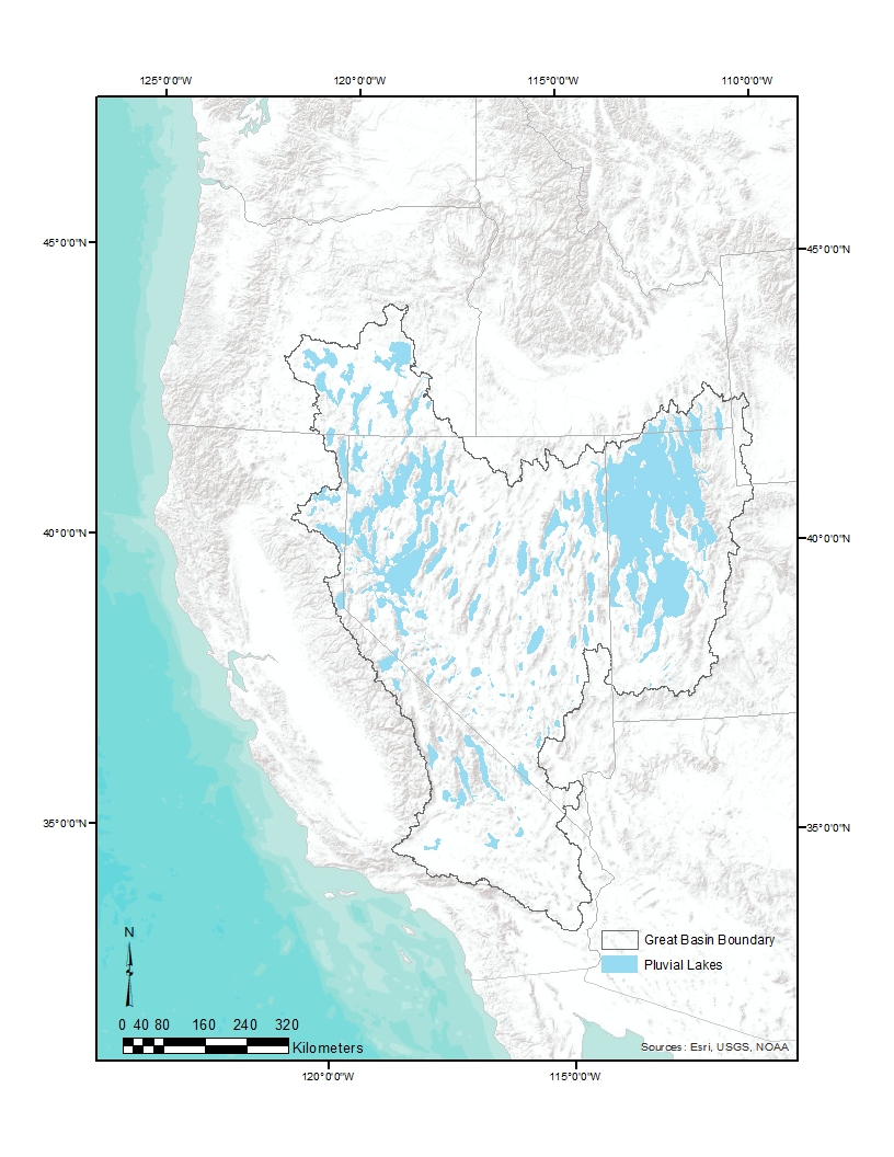
Fig.1. Overview of the hydrological Great Basin with its Late Pleistocene pluvial lakes in light blue.
Courtesy Keck Museum at the University of Nevada Reno.
-
![]()
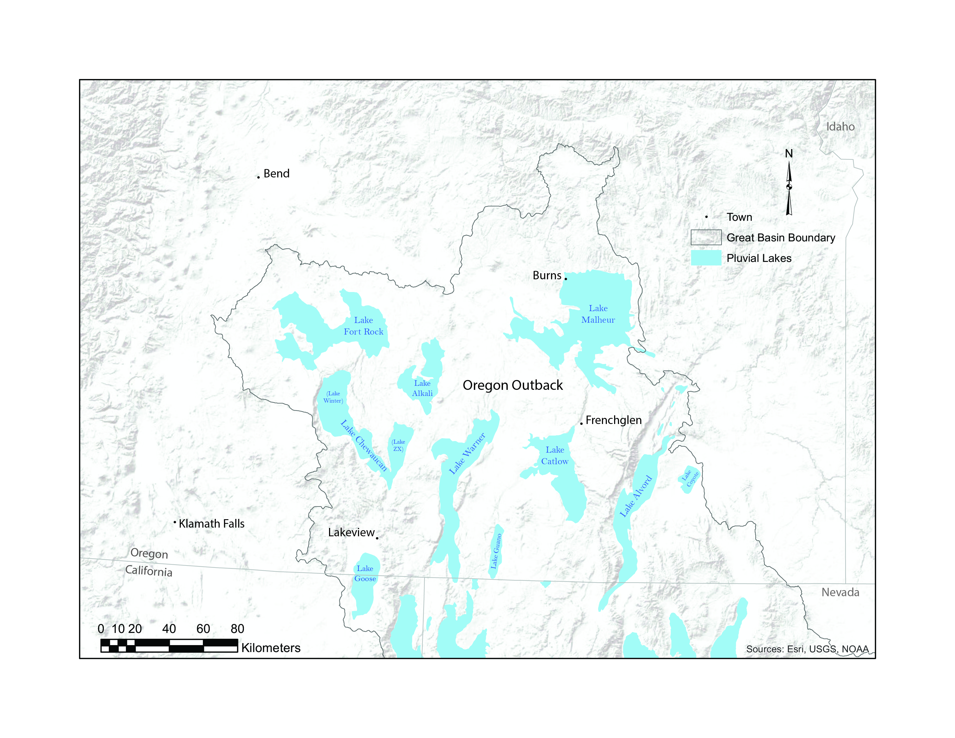
Fig.2. Southeastern Oregon’s Late Pleistocene pluvial lakes.
Courtesy Teresa Wriston
-
![]()
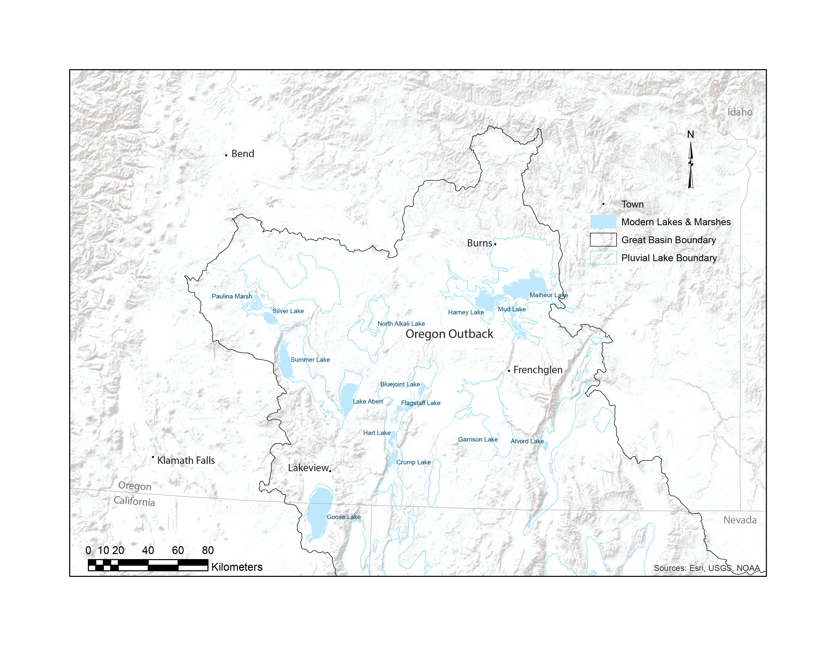
Fig.3. Modern lakes and marshes in southeastern Oregon that are within the footprint of Late Pleistocene pluvial lakes (outlined in light blue).
Courtesy Teresa Wriston
Related Entries
-
![Climate Change in Oregon]()
Climate Change in Oregon
Within a few hundred miles in Oregon, you can see snowy volcanoes, parc…
-
![Fort Rock Cave]()
Fort Rock Cave
Fort Rock Cave is located in a small volcanic butte approximately half …
-
![Fort Rock (formation)]()
Fort Rock (formation)
Fort Rock is a volcanic citadel at the western end of the Fort Rock Val…
-
![High Desert]()
High Desert
Oregon’s High Desert is a place apart, an inescapable reality of physic…
-
![Mount Mazama]()
Mount Mazama
Mount Mazama is located in the southern part of the Cascade Range, abou…
-
![Paisley Caves]()
Paisley Caves
The Paisley Caves—more formally known as Paisley Five Mile Caves—in sou…

Map This on the Oregon History WayFinder
The Oregon History Wayfinder is an interactive map that identifies significant places, people, and events in Oregon history.
Further Reading
Allison, Ira S. Pluvial Fort Rock Lake, Lake County, Oregon. Portland, Ore.: Oregon Department of Geology and Mineral Industries, 1979.
Allison, Ira S. Geology of Pluvial Lake Chewaucan, Lake County, Oregon. Corvallis: Oregon State University Press, 1982.
Bedwell, Stephen F. Fort Rock Basin Prehistory and Environment. Eugene: University of Oregon Books, 1973.
Dugas, Daniel P. "Late Quaternary variations in the level of paleo-Lake Malheur, eastern Oregon." Quaternary Research 50 (1998): 276-282.
Freidel, Dorothy. "Paleolake Shorelines and Lake Level Chronology of the Fort Rock Basin, Oregon." In Archaeological Researches in the Northern Great Basin: Fort Rock Archaeology Since Cressman, edited by C. M. Aikens and D. L. Jenkins, 21-40. Eugene: Department of Anthropology and State Museum of Anthropology, University of Oregon, 1994.
Freidel, Dorothy. Chronology and Climatic Controls of Late Quaternary Lake-Level Fluctuations in Chewaucan, Fort Rock, and Alkali Basins, South-Central Oregon. Eugene: University of Oregon. 1993.
Gehr, K. D. Late Pleistocene and Recent Archaeology and Geomorphology of the South Shore of Harney Lake, Oregon. Portland. Ore.: Portland State University, 1980.
Jenkins, D. L., T. J. Connolly, and C. M. Aikens. Early and Middle Holocene Archaeology of the Northern Great Basin. Eugene: University of Oregon, 2004
Licciardi, J. M. "Chronology of latest Pleistocene lake-level fluctuations in the pluvial Lake Chewaucan basin, Oregon, USA." Journal of Quaternary Science 16 (2001): 545-553.
Orme, A. R. "Pleistocene pluvial lakes of the American West: A short history of research." In History of Geomorphology and Quaternary Geology, edited by R. H. Grapes, et al., 51-78. London, Eng.: Geological Society of London, 2008.
Reheis, M .C., K. D. Adams, C. G. Oviatt, and S. N. Bacon. "Pluvial lakes in the Great Basin of the western United States." Quaternary Science Reviews 97 (2014): 33-57.
Weide, D. L. Postglacial Geomorphology and Environments of the Warner Valley-Hart Mountain Area, Oregon. Los Angeles: University of California, 1975.
Wriston, T. A. The Weed Lake Ditch Site: An Early Holocene Occupation on the Shore of Pluvial Lake Malheur, Harney Basin, Oregon. Reno: University of Nevada, Reno, 2003.
Wriston, T. A, and G. M. Smith, 2017. "Late Pleistocene to Holocene history of Lake Warner and its prehistoric occupations, Warner Valley, Oregon." Quaternary Research 88 (2017): 491-513.
Young, D. C. Late Holocene Landscapes and Prehistoric Land Use in Warner Valley, Oregon. Reno: University of Nevada, Reno, 1998.