The McKenzie Pass summit, named for the McKenzie River, is located on the scenic McKenzie Pass Highway (Route 242) just west of the Dee Wright Observatory. Until the 1860s, the pass was an Indian trail that was later used for driving cattle over the Cascades. Few immigrants to the Willamette Valley crossed McKenzie Pass because the large lava flows and steep terrain made wagon travel almost impossible. The few white settlers who did attempt to cross the flows usually had to abandon their wagons and complete their journey on foot. The elevation of McKenzie Pass is 5,324 feet.
The first recorded trip over the Cascades in this region was in 1853 by a group of immigrants on horseback—part of the Elliot and McClure wagon train, which became known as the Lost Wagon Train. The group was lost in the mountainous area near the Three Sisters and eventually made their way down the McKenzie River to Springfield.
In 1862, Felix Scott Jr. traveled from the lower McKenzie Valley with some 50 men and 900 cattle over the old Indian trail past Belknap Springs, then up Scott Creek and over the summit to Idaho. His route was known as the Scott Trail. Several of the men with Scott’s party were soon seeking an easier way across the Cascades. "They will change the route so as to avoid some of the worst places on the present trail,” the Oregon State Journal reported on May 14, 1864. “The principal hill—ascending the mountain on this side—will be entirely avoided by the new route.” The new route diverted travelers along Lost Creek, then up Deadhorse Grade toward the summit.
The McKenzie Salt Springs and Des Chutes Wagon Road Company, established in 1871 at Eugene, followed the new route. Like the modest ferry tolls in the lower valley, the company also collected tolls at McKenzie Bridge, then Blue River. Reportedly, the first emigrant wagon train crossed on the new toll road in October 1874.
By 1898, the entire route became a county road named the McKenzie and Eastern Oregon Road. The road was in poor shape until federal money became available in 1920 for road improvements. By 1925, when the route became State Highway 126, the road had been improved and widened between Blue River and Sisters, although at the time it was still mostly unpaved. The first automobile struggled over the summit in 1910.
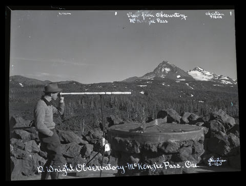
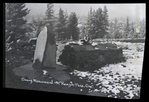
From the 1920s through the 1950s, the highway above McKenzie Bridge became known for its scenic beauty, especially in the fall when vine and big leaf maples transformed the fir forest into a blaze of color. Farther up the old highway, the road passes Scott Lake and Frog Camp, access points for the Three Sisters Wilderness area and adjacent lava fields. At the summit of the old pass, at the Dee Wright Observatory, are a popular peak finder and interpretive lava trail. The observatory, named after Forest Service packer Dee Wright, was hand-built from native lava rock in 1934-1935 by the Civilian Conservation Corps company at Camp Belknap. Craig Monument, located along the highway just west of the summit, was named after pioneer mail carrier John T. Craig, who perished at a cabin at that spot while carrying mail in December 1877.
By then known as the McKenzie Pass Highway 126, the road continued as one of a handful of routes from Eugene over the Cascades until the late 1950s, when construction began on an alternate route. The new highway section, the Clear Lake Cutoff, routed most traffic above McKenzie Bridge to the South Santiam Highway (U.S. 20) by way of Clear Lake. When the alternate highway was completed in 1964, the now bypassed McKenzie Pass route was named a scenic highway and given the present Oregon Route 242 designation. In 2011, the route was listed on the National Register of Historic Places. The McKenzie Pass Highway is usually open from early July to early November, as snowfall blocks the highway during the winter months.
-
![]()
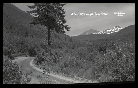
Along McKenzie Pass, Oregon. Middle Sister and North Sister mountains are in the background.
Oregon Historical Society Research Library, Digital Collections, OrgLot1275_B2_Christian_S-161
-
![]()
D. Wright Observatory, McKenzie Pass.
Oregon Historical Society Research Library, Digital Collections, OrgLot1275_B2_Christian_S-160
-
![]()
Craig Monument, McKenzie Pass.
Oregon Historical Society Research Library, Digital Collections, OrgLot1275_B3_Christian_S102
Map This on the Oregon History WayFinder
The Oregon History Wayfinder is an interactive map that identifies significant places, people, and events in Oregon history.
Further Reading
Williams, Gerald W. "McKenzie River Names." Unpublished manuscript, n.d. Corvallis: Oregon State University Library Archives.