In 1900, Colonel Frank H. Ray persuaded his brother, Dr. C.R. Ray, to inspect a gold mine in southern Oregon for possible purchase. With a positive report, the two brothers bought the Braden Mine near the town of Gold Hill in the Rogue Valley and acquired with it the rights to a power site to be constructed on the Rogue River to supply the mine with electricity.
A wealthy New Yorker, Colonel Ray was an organizer and vice-president of the American Tobacco Company and had no problem raising the money to build the power station. The capital came not only from the company, but also from selling securities on the New York Stock Exchange.
The City of Gold Hill wanted too much money, however, and the brothers chose Tolo as the site for their dam, four miles above the city, where the river leaves the valley basin. In 1902, work started on the original Gold Ray Dam by first constructing a cofferdam to divert the rushing Rogue River. Workers then jammed large timbers into the bedrock and backfilled with rocks to create a solid log barrier that held back the water.
When completed, the dam was 17 feet tall and 350 feet long. The impounded river lifted the Rogue's surface enough to divert it through a powerhouse, whose unique rope-driven turbines created the first hydroelectric power in southern Oregon. Drawn off the river’s north side, the water turned a series of pulleys that used 1,600 feet of one-and-three-quarter-inch-thick rope to rotate the generators.
Electricity first flowed over the wires in 1904. The Ray brothers saw more potential in selling electricity than in gold mining, and their Condor Water and Power Company furnished power to Grants Pass, Gold Hill, Medford, Jacksonville, Central Point, and Ashland. The availability of inexpensive power was instrumental in powering numerous businesses, ranging from saw and flour mills to machine shops. Businesses, retail stories, restaurants, and residences now had power, which allowed southern Oregon to attract population and develop with the rest of the state.
The plant produced hydroelectric power for nearly seventy years. In 1921, the dam became part of the California-Oregon Power Company, which later became Pacific Power (now PacifiCorp). The utility replaced the timber dam with a concrete one in 1941 and added a fish ladder and fish-counting station. Over time, power grids from outside the area as well as large generator stations on land reduced the need for the power, and the utility closed the facility in 1972. The company then deeded the dam, powerhouse, and twenty-seven acres to Jackson County.
In late 2009, the county awarded a contract to conduct an environmental assessment on the potential demolition of the 105-year-old dam. To be completed by the end of 2010, this study will review three alternatives: no action, the dam's removal, or rebuilding the current structure.
The power once so necessary to the area’s development had become an environmental problem: an estimated 400,000 cubic yards of silt and muck trapped by the dam could contain heavy metals or other contaminants such as mercury, arsenic, and pesticides. Once these issues are resolved and full funding is secured for the demolition, the dam will likely be removed, and the Rogue will once again flow freely for 157 miles into the Pacific Ocean.
-
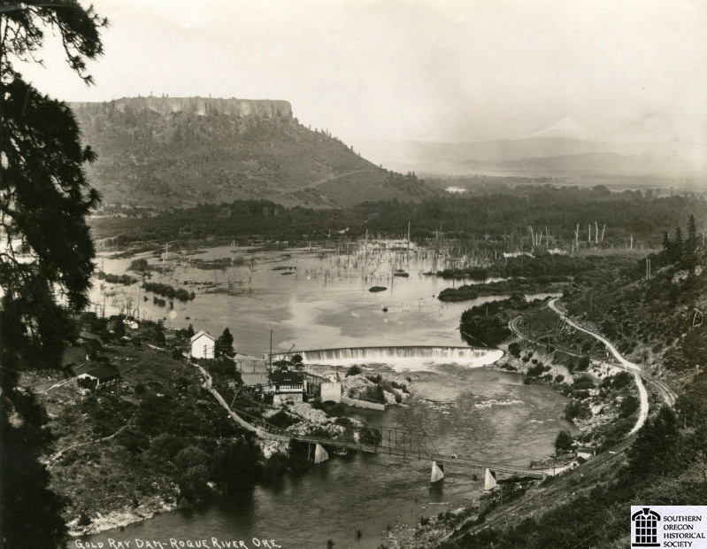
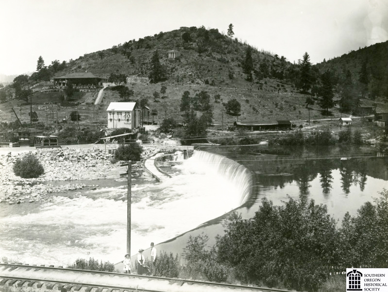
![Gold Ray Dam, about 1910.]()
Gold Ray Dam, ca 1910.
Gold Ray Dam, about 1910. Southern Oreg. Hist. Soc., SOHS01i_16150
-
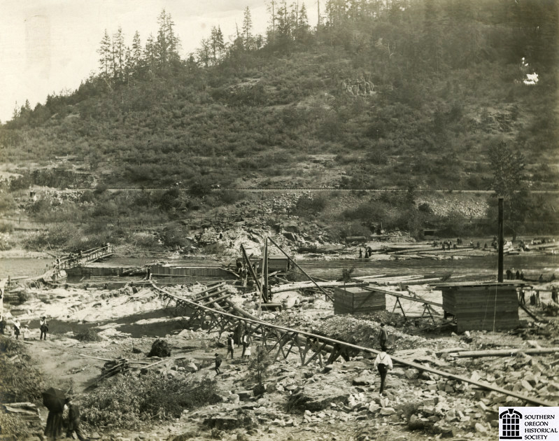
![Gold Ray Dam construction, 1903 or 1904.]()
Gold Ray Dam, construction, ca 1903-1904.
Gold Ray Dam construction, 1903 or 1904. Southern Oreg. Hist. Soc., SOHS01i_12504
-
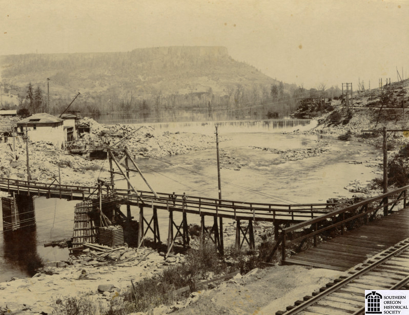
![Gold Ray Dam powerhouse construction, 1903 or 1904.]()
Gold Ray Dam, pwr house construction, ca 1903-1904.
Gold Ray Dam powerhouse construction, 1903 or 1904. Southern Oreg. Hist. Soc., SOHS01i_20625
-
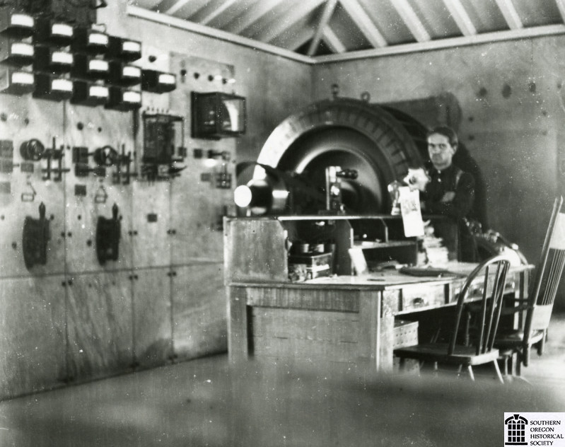
![Gold Ray Dam powerhouse interior.]()
Gold Ray Dam, pwr house interior.
Gold Ray Dam powerhouse interior. Southern Oreg. Hist. Soc., SOHS01i_16659
-
![Gold Ray Dam, 1912.]()
Gold Ray Dam, 1912.
Gold Ray Dam, 1912. Southern Oreg. Hist. Soc., SOHS01i_16658
Related Entries
Related Historical Records
Map This on the Oregon History WayFinder
The Oregon History Wayfinder is an interactive map that identifies significant places, people, and events in Oregon history.
Further Reading
Coldwell, O.B. “Beginnings of Electrical Power in Oregon.” Oregon Historical Quarterly (March 1930) 31.1, p. 34.