Overview
Cartography of Oregon, 1507-1848, by James Walker.
The cartographic history of Oregon as a place in the Pacific Northwest began long before European visitation to the region. Mapmakers initially conceptualized the presence of a separate North American continent in 1507, some 234 years before the first recorded sighting of a landmark on the Pacific Northwest coast in 1741 and 315 years before the word Oregon identified a region on a map in 1822.
Mapmakers always drew on a variety of sources to represent territory. For the Pacific Northwest, these included actual and apocryphal accounts of explorations as well as long-established geographical concepts of a navigable water passage above the continent (the Northwest Passage) or through it (the River of the West). Thus, ideas of what a place looked like were shaped by ideas about how one could get there.
Voyages of Russians, Spanish, English, French, and Americans in the eighteenth century resulted in a reasonably accurate cartographic rendering of the North Pacific coast. During the first half of the nineteenth century, sources of information for mapmakers were explorers, statesmen, politicians, and entrepreneurs; and maps reflected ambitions, ideologies, and attempts to claim, name, and tame the region. Read the full entry
Content Standards
- HS.41 Use maps, satellite images, photographs, and other representations to explain relationships between the locations of places and regions and their political, cultural, and economic dynamics.
- HS.42 Use geographic data to analyze the interconnectedness of physical and human regional systems (such as a river valley and culture, water rights/use in regions, choice/impact of settlement locations) and their interconnectedness to global communities.
- HS.43 Analyze the reciprocal nature of how historical events and spatial diffusion of ideas, technologies, and cultural practices have influenced migration patterns and the distribution of human population.
- HS.46 Assess how changes in the environmental and cultural characteristics of a place or region influence spatial patterns of trade, land use, and issues of sustainability.
- HS.49 Assess the impact of human settlement activities on the environmental and cultural characteristics of specific places and regions.
- HS.52 Identify and analyze how map-making, zoning, and other policy decisions create social, political, and economic realities for various population groups.
Additional Sources
Oregon Encyclopedia Entries
Lang, William L. "James Cook" The OE
Lang, William L. "Lewis and Clark Expedition
Lang, William L. "George Vancouver" The OE
Walker, James. "Cartography of Oregon, 1507 - 1848" The OE
Walker, James. "Tanner Map of 1822 The OE
Books
Burden, Philip. The Mapping of North America: A List of Printed Maps 1511-1670. London: Raleigh Publications, 1996.
Hayes, Derek. Historical Atlas of the Pacific Northwest. Seattle: Sasquatch Books, 1999.
Wagner, Henry. The Cartography of the Northwest Coast of America to the Year 1800 (Reprint) Amsterdam: N. Israel, 1968 (1937).
Wheat, Carl. Mapping the Transmississippi West. San Francisco, Calif.: The Institute of Historical Cartography, 1959.
Additional Lesson Plans
Digital Public Library of America. Primary Source Sets Lesson Plan. The Lewis and Clark Expedition
Cite
The OE Staff. The Changing Shape of North America. 2020. Retrieved from The Oregon Encyclopedia, https://www.oregonencyclopedia.org/packets/3. (Accessed July 16, 2026.)Teacher Guide
-
Have students read about and examine Map #1 The Russian Discoveries What advantages did Russians have over Western Europeans in their attempts to explore and map the Northwest Coast?
-
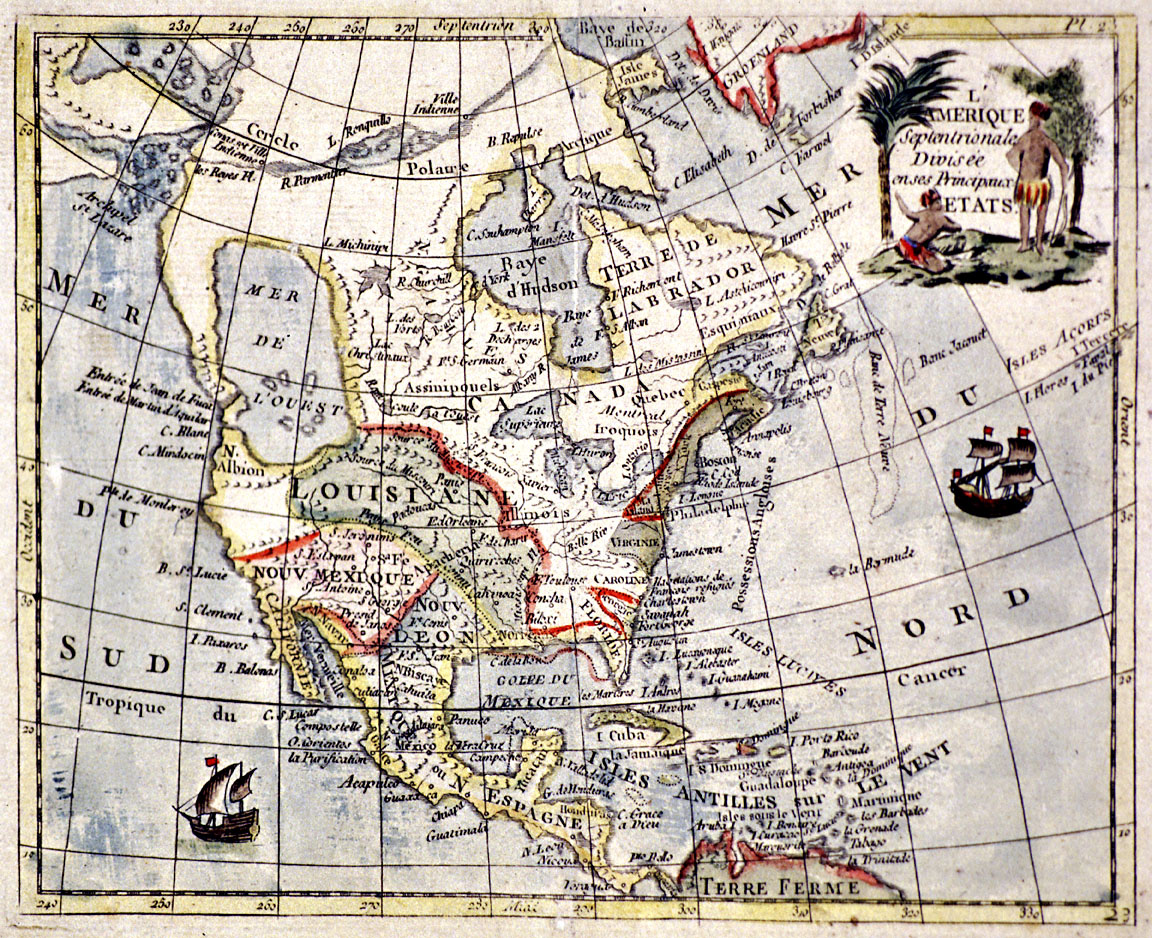
Have students read about and examine Map #2 L'Amerique Septentrionale and Map #3 Carver's New Map of North America Why was the discovery of a Northwest Passage so important to explorers?
-
Have students read about and examine Map# 4 Map of the Americas, 1606 and Map #5 An Accurate Map of North America, c. 1780 What do maps 4 and 5 and the previous three maps reveal about Russian, European, and American ideas of the Far West before the end of the eighteenth century?
-
Have students examine and read about Map # 6 New Map of North America, 1806 and Map # 7 Map of Lewis and Clark's Track How did Lewis and Clark's overland exploration of the Far West change the world's understanding of its geography?