As white settlement grew in the lower Willamette Valley during the mid-1800s, so did the desire for a road to the seaport of Astoria that would provide inexpensive and convenient access to lucrative California markets. Traversing the rugged mountains in that part of the Oregon Territory promised to be difficult and costly, and attempts to fund the road in 1843 through the Provisional Government, and in 1848 through the Territorial Government, failed. Eventually, local supporters persuaded the U.S. Congress to fund the survey and construction of a military road from Salem to Astoria. In the spring of 1855, the Army Corps of Topographical Engineers commissioned Lt. George Derby to lead the survey party. He and his crew arrived in Astoria in July 1855.
The Corps had allocated $30,000 for the project, and Derby began the arduous field survey with a crew of ten men and six pack animals. Following the initial general reconnaissance survey from Astoria to Salem, a more detailed and accurate instrument survey began in August 1855. The first fifty-four miles of the route from Salem followed existing pioneer roads (this portion closely followed today’s State Highways 221 and 47). When the crew reached the settlement of Harpers, just west of present-day Gales Creek, the person making notations in the survey record wrote: “Starting Point in the Wilderness.”
The next fifty miles of the route crossed several high ridges, such as today’s Giveout Mountain and Saddle Mountain, which proved to be more of a challenge than anticipated. Some sections were thick with underbrush and bracken ferns that were a result of recent wildfires, but much of the terrain was heavily timbered with Douglas-fir, hemlock, and cedar that were over 200 years old. The crew encountered areas of blowdown that were impassable, and they were forced to deviate from the proposed route. They also crossed numerous rivers and streams, many choked with debris from high water and landslides.
Construction of the Salem-Astoria Military Road began in 1856, eight months behind schedule, and it was plagued with ever-increasing costs and interruptions caused by lack of funding. From Astoria, a wagon road was completed to the crossing of the Nehalem River near Elsie, and the route from Salem was completed to the community of Timber. When federal funding ceased in 1860 due to the outbreak of the Civil War, the road became the responsibility of the counties. The middle portion of the road was never constructed, but it still served as a route for pack animals and stock driving.
Although the road was never used for any military operation, the Salem-Astoria Military Road did serve as a significant force for settlement in northwest Oregon, leading to the establishment of Gales Creek, Timber, Elsie, Hamlet, and Olney. Though the Salem-Astoria Military Road was reclaimed by nature before they were built, the Wilson River Highway (OR 6), from its Tualatin Valley Highway (OR 8) junction to Glenwood and Timber Road, from Glenwood to the bottom of the switchbacks south of Timber, closely follow its route.
-
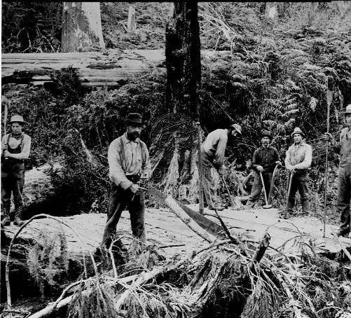
![]()
Homesteaders work together to build a plank road through the woods to Hamlet, 1908.
Oregon Historical Society Research Library Oregon Journal Collection 005687
Related Entries
Map This on the Oregon History WayFinder
The Oregon History Wayfinder is an interactive map that identifies significant places, people, and events in Oregon history.
Further Reading
Fick, Lawrence R. and George E. Martin. "A Road in the Wilderness: The Salem to Astoria Military Road." Forest Grove: Oregon Department of Forestry, 2002.