Geocaching is a high-tech version of the classic scavenger hunt in which the entire planet serves as the playing field. The activity was created in Oregon and, within just eleven years of the first event, participation had grown from one cache and a handful of players to 1,421,753 active caches and more than five million participants around the world.
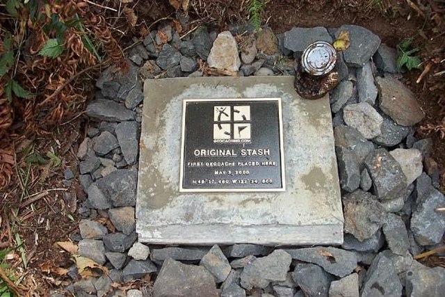
The first geocaching event in the world took place on May 3, 2000, near Beavercreek in Clackamas County. Computer consultant David Ulmer placed the inaugural cache as a way to test the accuracy of the U.S. military’s global positioning system (GPS). A few days before, President Bill Clinton had issued an executive order that increased the availability of GPS satellite signals to the general public, which improved system accuracy for nonmilitary users from a circumference of about 300 feet to about 30.
Ulmer advertised his test to an online community of GPS users as the Great American GPS Stash Hunt. Popularity of the activity spread quickly on the Internet, and within a month, participant Matt Stum had coined the term “geocaching”—geo, Greek for the earth, and cache, French for to stow or hide. In early September, Seattle-based web designer Jeremy Irish launched the website geocaching.com to centralize the activity of what was then 75 active participants. By the end of 2000, almost 300 caches had been placed in Oregon, more than 300 in Washington, and nearly 10,000 in 86 countries.
Ulmer’s original cache was a bucket containing a cassette recorder, a slingshot, a paperback book written by Ross Perot, and a videotape of George of the Jungle. Michael Teague of Vancouver, Washington, was the first person to find Ulmer’s inaugural stash; he found it within a day of Ulmer’s announcement, at N 45° 17.460 W 122° 24.800.
Participation in geocaching requires Internet access and a handheld GPS unit or compatible smartphone. After registering at a designated website and downloading the longitude and latitude of a given cache, a player uses the GPS unit as a guide to the intersection of the coordinates in the physical world. Once in the vicinity of the coordinates, players scour the area for the cache.
A cache contains trinkets, which are usually sealed in a plastic or metal container, and a logbook where players record the date and time they find the cache. Objects are usually cached on public property, and caches are often located in rural or wilderness areas. In early 2010, for example, about 200 caches were located within five miles of downtown Medford. Some caches are even underwater.
Occasionally, a cache contains a Trackable, an object with an identifying number that can be tracked on the geocaching.com website. In addition to following the travels of Trackables online, players are encouraged to post their geocaching adventure photos and stories.
Geocaching etiquette has changed over the years, partly in response to damage to and restrictions on public lands. Players are supposed to add an item for every item taken from a cache, respect private property, avoid trampling vegetation, and pack out trash found in the vicinity of the cache. To help preserve sensitive locations, most geocachers no longer place caches in designated wilderness areas.
Many geocachers engage in the activity with their families, and for many it fosters a strong sense of community. The website oregongeocaching.com, for example, serves as a community forum for the state. In April 2010, during the ten-year anniversary of the creation of geocaching, players held a celebratory gathering at McKee Bridge, about twenty-five miles southwest of Medford.
-
![]()
Original Stash. First geocache placed here, near Beavercreek, OR, 2000. Photo take in 2018.
Courtesy groundspeak. Wikimedia Commons.
Map This on the Oregon History WayFinder
The Oregon History Wayfinder is an interactive map that identifies significant places, people, and events in Oregon history.
Further Reading
Geocaching. www.geocaching.com/default.aspx.
Preusch, Matthew. “GPS-Driven Geocaching Falls Astray of Plans for Badlands East of Bend.” Oregonian, Feb. 11, 2005, p. A1.