
Located between John Day and the Elkhorn Mountains, the Greenhorn Mountains are a low uplift within the Blue Mountains. Their highest point is Vinegar Hill, at 8,300 feet. The town of Greenhorn, at 6,300 feet in elevation, is Oregon’s highest incorporated city. It served as a gold-rush boomtown from the 1865 discovery of gold at Robinsonville, about five miles to the north, until the closure of the large mines at Ben Harrison Peak, in about 1940.
The name Greenhorn stems from a large green-colored monolith, known as the “green horn,” that was visible for miles and which served as a directional marker in many mining claim descriptions. Most of the Greenhorns are now protected as part of the North Fork, John Day River Wilderness Area. Although the range is small, about ten miles long and eight miles wide, it harbors a disproportionate amount of Oregon’s geologic and mining history.
The geology of the Greenhorn Mountains is part of the Baker Terrane rocks that were deposited and developed far from North America and then were added to the continent through plate tectonic processes about 140 million years ago. Most of the Greenhorns are a zone of faulted, folded, and mixed rocks called a mélange. There is no stratigraphic order, and the rocks range in age from Devonian to Jurassic. These large chunks of rock, up to a kilometer or more in diameter, are called “knockers” by geologists. They vary in type and include gabbro, chert, argillite, greenstones, and limestone. The matrix that holds them together is the green, scaly rock serpentinite—actually metamorphosed peridotite, which is rock from the Earth’s upper mantle. The best interpretation is that the Greenhorn mélange represents an ancient subduction zone, a conclusion that is corroborated by the presence of relatively high-pressure, low-temperature metamorphic rocks that are only produced in subduction zones.
Two intrusions of granitic rocks—Sunrise Butte and Ben Harrison Peak—occupy the western part of the Greenhorns. Dated at 150 to 160 million years ago, they were the likely source of the heat and fluids that generated the Greenhorns’ copious gold deposits. Major mines included the Ben Harrison, Bonanza, Red Boy, and Pyx. Many placer mines and hydraulic mines operated as well. Chinese laborers and, later, Chinese miners worked the area and built an extensive system of ditches to bring water from streams to dryland placer operations.
About 80 gold mines operated in the Greenhorn District. Not all were productive. Total gold produced in the district likely exceeded $3 million, including $1.5 million from placer deposits, $900,000 from the Bonanza mine, and $1 million from the Red Boy mine. Placer miners and prospectors continue to explore the area and to file and work claims.
-
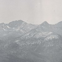
![South slope of Greenhorn Mountains]()
South slope of Greenhorn Mountains.
South slope of Greenhorn Mountains Courtesy USGS, U.S. Dept. of Agriculture, photography by J.T. Pardee
-
![Red Boy Mill, 1900]()
Red Boy Mill, 1900.
Red Boy Mill, 1900 Courtesy U.S. Depart. of Agriculture, photograph by W. Lindgren


Map This on the Oregon History WayFinder
The Oregon History Wayfinder is an interactive map that identifies significant places, people, and events in Oregon history.
Further Reading
Bishop, Ellen M. In Search of Ancient Oregon. Portland, Ore.: Timber Press, 2004.
Brooks, Howard. A Pictorial History of Gold Mining in the Blue Mountains of Eastern Oregon. Baker City: Baker County Historical Society, 2007.
Potter, Miles. Oregon’s Golden Years. Caldwell, Id.: Caxton Publishers, 1976.